Northern Loop, Mount Rainier National Park
September 24-26, 2004
With my first week at Pierce College done, I was looking for a way to celebrate and so packed my gear and left, directly after classes ended, for Mount Rainier National Park. I was going to hike the Northern Loop trail and break in a new pair of mountaineering boots that I had bought the previous week in Vancouver. Perhaps it wasn't terribly clever to do so on such a long (35ish miles) weekend trip, but I was going to do so anyways. With perfect weather, I made the drive to the park, stopping to pick up backcountry permit, and parked at the Sunrise complex high on the slopes of the famous moutain. Autumn was in full swing and the reds and golds of the landscape provided a drastically different picture of the park than when I came through in August of 2003 on the PCT.

There were a lot of people day hiking in the area, but once I got about a mile down the trail the crowds vanished and I had the trail to myself. The trail stayed high on ridgelines before dropping away into a beautiful valley where I camped for the night at Berkeley Park , only a little over three miles in. In the morning, I climbed up and out of Berkeley Park and reached the magnificent plateau of Grand Park. The stunning mountain towered over the golden fields, its white mass stunning in the early morning air.

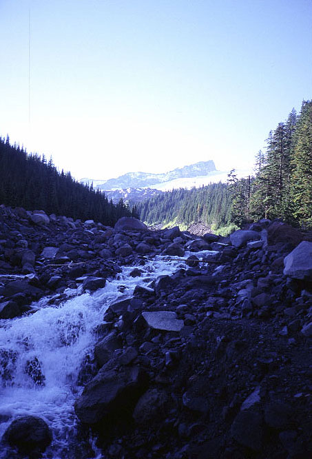
My feet were already hurting slightly from the boots and my pace was noticeably slower than usual when I began the plunging descent down to the White River, out of which I would have to climb shortly. The descent provided many spectacular views of the mountain as it switchbacked its way down to the river bottom.

There was a sort of bridge across the White, but I had to do some delicate rockhopping to get to it, along with some minor fording. The trail now turned to climb a few thoursand feet up and out of the valley, but I barely noticed the effort thanks to the stunning scenery, from the big mountain and lots of little flowers to the fall-colored landscape. I topped out and strolled for a while before taking a long lunch break near the Yellowstone cliffs, which are an odd rock formation, according to my guidebook, for this particular area. They didn't seem too strange to me, but were at least pleasing to the eye.

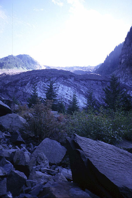
The roller coaster continued as the trail plummeted down to the Carbon river, where I began to run into day hikers for the first time. My feet were really beginning to bother me at this point and I was not in a particularly pleasant mood, despite the fine surroundings. With a trailhead close by and not a cloud in the sky, throngs of people had made the short walk from the Carbon river road out to this part of the park where a glacier could be viewed up close. The Carbon glacier was mostly covered in rubble, but one could still see some ice and this was an attraction, it seemed. I climbed up and out of the main area for a while until I could rest in peace and quiet. My feet were really awful at this point and each step was a minor exercise in pain management. I knew this would happen going into the trek, but had ignored what my mind told me would happen in the hope that it would not.
I struggled up the last part of the hill, very tired and with sore feet, mostly ignoring the longer distance dayhikers who tried to start up a conversation. I was done in, but hadn't reached camp yet and so had to struggle on. I took a final break in a large, open field directly beneath the massive volcano and contemplated a future climb, trying to focus on the beauty around me instead of my tired body and sore feet. But, beauty doesn't work this way. I limped the rest of the way to Mystic Camp, where several other parties were encamped, and collapsed, happy to be done with walking for the day. After dinner I checked out my feet to find out why I was in so much discomfort. I found some blisters and some blood where one of my toe nails had cut open the side of my big toe. But, the main culprit seems to have been the added structure of the stiff boots themselves. I'm used to hiking in trail runners which have a lot flex in them. My feet and ankles are free to move about as they see fit, and in the confines of the boots they were not happy in the least.
In the morning I felt much better and set off with a smile, replacing yesterday's stern grimace with something a bit more appropriate to the environs. I quickly dropped down and crossed the runout from the Winthrop glacier before making the final big climb of the trip back up to the Sunrise area. I began to meet dayhikers once more, though I was now able to converse with them. Everyone, myself included, was in awe of the land. Indeed, the Sunrise area is one of the prettiest places I've ever been. It is certainly one of the easiest to access, as the hordes of hikers that I encountered on my way down to my car indicated.

The Walmart sized parking lot at Sunrise was almost competely full and the one bathroom stall, in front of which I had parked, had a line up of twenty people. So, I stripped down in public, not particularly caring who was about, and changed into clean clothes for the drive home. My feet were truly a wreck, but the boots were now on their way to being broken in and I had had a tremendous weekend, perhaps the last good weather one for the season.
Logistics
The Northern Loop trail begins at the Sunrise complex, located on the north side of the park, high up on the slopes of Mount Rainier. You'll need to pay $10, or have an annual pass (Golden Eagle, etc) to drive into the park. You can reserve slots in the campgrounds in advance, although I didn't do this and had no problems. The Northern Loop trail is 35 miles long and features a lot of elevation change (about 8500 feet of up, and 8500 feet of down). I hiked in a few miles on Friday night, then put in a little over 20 miles on Saturday, leaving me with a short day on Sunday. This is faster, I believe, than normal and the ranger who issued me the permit was a little skeptical that I would finish the loop. The trail passed through some beautiful terrain, including close ups of two large glaciers and many stunning views of Mount Rainier itself.
From Lakewood, take SR 512 east, following the signs for the Sunrise area of Mount Rainier, through Puyallup. Hop on SR 410 and take this through the towns of Buckley and Enumclaw, all the way to the park itself. You'll pass Crystal Mountain Ski Resort just before the turn off for Sunrise. Just after you make the turn, there is a ranger station at which you can get permits. Continue on the park road and follow the signs to Sunrise, which is at the end of the road, way up from the valley floor. Park as far down in the parking lot as you can, as the trail starts from that end of things. Climb up to the ridge above you on any one of several trails, then tend toward the left, heading to Frozen Lake. Lots of trails crisscross the region, but finding your way along the Northern Loop trail is very easy.