Mount Si, State Conservation Area
November 18, 2006
I had told Julie that I was going to do something artistic instead of athletic this weekend, but that plan went out the window when I saw, gasp, sun and no rain on Saturday morning. I quickly stuffed a few things in my pack and made the drive out to Mount Si. I had not yet been up this most popular of "peaks" in the Sound area, for good reason. Everything I had heard about it sounded bad: Over run, boring, almost paved. However, it did promise a workout, and after spending most of the last few months rock climbing, this wasn't something to be overlooked.
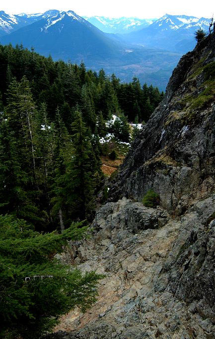
The trailhead wasn't as crowded as I thought it might be, and I only had to park three rows back from the front (out of four). Rather than treat the hike as a full on conditioner, I carried light pack but wore my mountaineering boots. Setting off at a lope, I decided not to push at a 100%, but rather at a rate that I could still think at. The trail was, indeed, almost paved and someone with strong arms could just about roll a wheel chair up it. There were no views to be had, other than the forest, third or fourth growth, and all the hikers that I passed (twenty six going up, about thirty coming down). But I did sweat a lot and built some strength in my legs during the 78 minutes it took to get to the top. For kicks, I went over to the Haystack, the prominent rock summit of Mount Si, and began the scramble to the top. High, cold winds and the fact that I was alone turned me back about fifteen feet from the top and I went, instead, in search of a slightly more sheltered viewpoint.
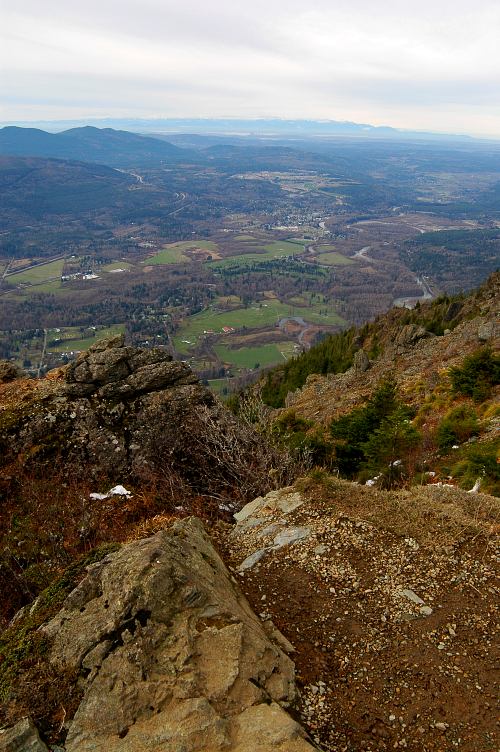
I found it, oddly enough, at Snoqualmie Viewpoint, which was open and exposed but surprisingly had no wind. There was a pleasant view down into the Snoqualmie Valley and, further, to downtown Seattle and the Olympics. I threw on a downjacket and hat for warmth and sat on the convenient bench, not so much to rest as to soak up time in a high place. Despite having passed many people on the way up, there was a distinct lack of crowds here at the top. After ten minutes, I was joined by David, a recent transplant from Virginia who had transfered out to work for the local FEMA branch. Our brief, "Hello, how are you?" turned into a forty minute chat about climbing, hiking, the Appalachian Trail, and other outdoor topics. When I mentioned with some disgust the sprawl coming out of Seattle, David only laughed and painted a picture of the East Coast for me.
I had been up top for nearly as long as it took me to get up to it, so it seemed like a good time to return down to the car and the drive home. David and I took a sedate pace down the ramp, getting passed many times by people in blue jeans and hiking boots who were running down. I didn't remember seeing them up top, so I wasn't sure where they came from. Nor was I sure where all the people I passed had gone. Of the twenty six, I saw only a handful on top. Maybe they just got bored and turned around. It didn't really matter, as David and I swapped storied from travel or climbing, work and life. Mount Si, despite my misgivings, had provided two good things: A little bit of exercise and meeting a fun new person.

Logistics
Mount Si is located near North Bend, WA and is the prominent peak, a foot hill of the Cascades, that you first see on I-90. From Lakewood, drive I-5 north to SR18 and take that to its junction with I-90. Drive I-90 east to Exit 31 and exit into the town of North Bend. Keep your eye on the peak. Make a left from the exit ramp and drive through town. You have several options of how to get to the trailhead, but all involve getting onto Mount Si Blvd. Either make the first right (which is Mount Si), or do what I did: Drive past it into town and take a circuitous, scenic route through little North Bend. Once on Mount Si Blvd, drive it for a bit till you see a hiker sign and make a left. Cross the bridge and drive past the Little Si trailhead for a couple of miles until you see the Mount Si trailhead. No pass is needed. If this sounds difficult, it really isn't. I didn't have directions and just followed my nose to the trailhead.
The trail to the top is 4 miles one way and gains about 3600 feet. It took me 78 minutes to get up, but a more moderate pace would have you at the top in 2 hours. Don't forget that you need to walk back down. The trail is broad, level, and easy to follow. It is popular, though why is a bit unclear to me as there isn't any real scenery until you get to the top. Much of it is snow free most of the year.