Silver Peak, Mount Baker - Snoqualmie National Forest
Annette Lake Route - October 27, 2007
Finally, a civilized alpine climb. Normally, an alpine climb follows an itinerary along the lines of something like this.
- Wake up at 3 am. Grumble a lot.
- Get coffee at the Union 76 at 3.50 am. Clerk inside is usually shaving.
- Meet climbing partners at 4 am. Remark on the cold and dark.
- Drive to the trailhead, complaining about how cold and dark it is the whole way..
- Start climbing at 6 am. Complain about how out of shape we are. Or, sometimes, about how out of shape the others are.
- Hike, climb, and be on the move for 14 hours. Maybe summit. Have a blast.
- Drive back to Lakewood and buy a can of Steele Reserve from the Union 76. Shaver guy is starting his shift.
- Pass out at 10:30 pm.
Well, that just isn't very civilized, even if it ends up being a lot of fun. Wayne, Kevin, and I waited until the luxurious hour of 7:30 am to start our drive and didn't even begin hiking until 9 am. Pretty posh, although I still complained about about being out of shape.
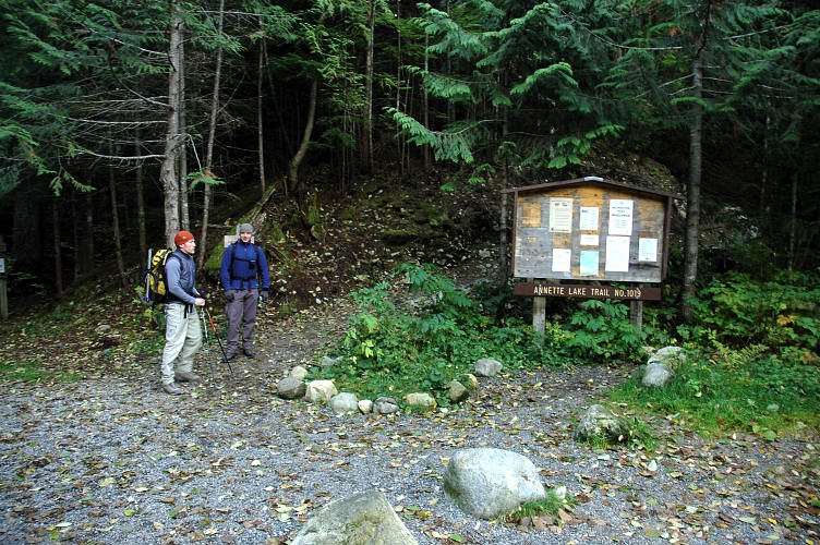
We were after Silver Peak, a minor 5600 foot mountain in the Snoqualmie Pass area just across I-5 from Granite Mountain, one of the most popular peaks in the area. But Granite has a trail all the way to the top and thus is a lot more popular than Silver Peak, which only has a trail 75% of the way. The three of us motored up the wide, smooth trail, making rapid progress and passing only one other group on the way to Annette Lake. I'd write something more prosaic, but the trail goes through new growth forest, which isn't all that interesting.

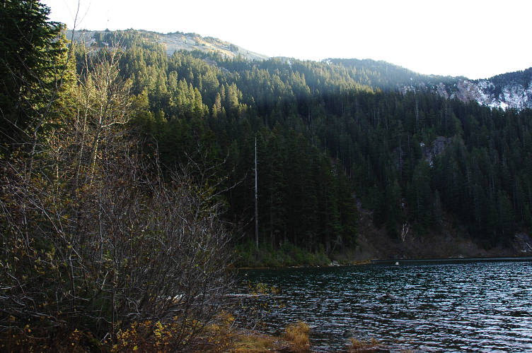
The prominent peak on the other side of Annette Lake had a fancy sounding name, but it wasn't our boy. It was lower and in the wrong place. Silver Peak is higher, but doesn't look like much from lakeside. In the below photo, you can see the lower ridge of Silver Peak. Doesn't look much like a mountain, eh? Well, it looks better from other sides. We needed the exercise anyways.
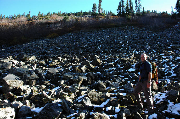
We found what we thought was a climbers trail about two hundred or so yard from the lake and hiked up it. It lasted for 10 feet. Not wanting to look for an actual track, we bushwhacked up the steep hillside for 15 minutes before the forest ran out and we gained the talus fields of the "ridge".
Kevin broke out the GPS so that we would know where to go on the way out. However, the GPS told us that we were standing at an elevation of 7000 feet. The GPS didn't come out again.
Normally talus field climbs are a royal pain because the rocks shift and you fall on you arse. At least I do. But the talus on this side of the mountain was actually stable and the slope of moderate angle. Little patches of snow kept things interesting.

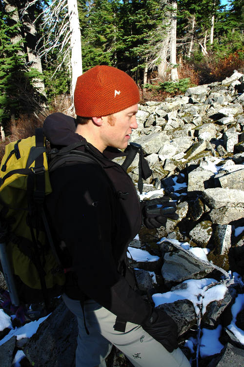
We plodded our way (climb just isn't the right word here) the slope, gaining elevation slowly but surely and topped out on the ridge within an hour of leaving the trail. The wind was howling along at 30 mph as we took a little break before making the last jaunt to the summit.

The summit is reached along a narrow ridge that can be heavily corniced in the winter time. We just had a little snow to slip on. The blasting wind kept our break short and we were quickly on the move. At first we stayed on top of the ridge itself, but eventually moved off to the lee, where we found a boot track. The boot track led around the backside of the peak and then up to the top of it. Technically challenging Silver Peak is not. Stunning views it does have. A large swathe of the Alpine Lakes Wilderness stretched out in front of us. Of course, so did the highway and ski resort. And numerous clear cuts. And Bellevue. And little bits of Seattle. A wilderness experience Silver Peak is not.

But, I especially liked the views. Wilderness is fine stuff, but I have a soft spot in my heart for getting high on top of a mountain and looking down, far down, upon the works of man. You get this on top of Mount Si, maybe the most "climbed" mountain in the state. But, the climb is on a trail that I could push myself up in a wheel chair and you don't get the views of Alpine Lakes. Here, I could spy a bunch of former climbs and climbs that I wanted to do.

Additionally, I could wheel about and get a grand view of Mount Rainier. The Big Fatty is always pretty when it has some snow on it. I better stop calling it the Big Fatty if I want to survive next summer.
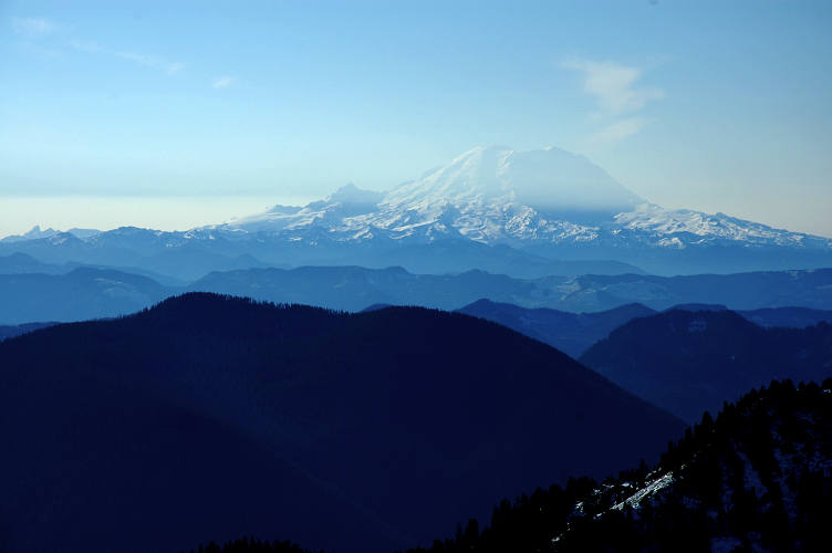
But, back to the Alpine Lakes. I had climbed Mount Thompson, shown as the sharp tooth on the far left of the below picture in July. I had climbed Mount Hinman, shown on the far left the August before. I wanted everything in between at some point. People drive for a long way and endure long bushwhacks to climb in the North Cascades and eschew these closer, local, smaller mountains. The Olympics get ignored for the same reason. This is fine with me as it keeps away lines like those on Forbidden.

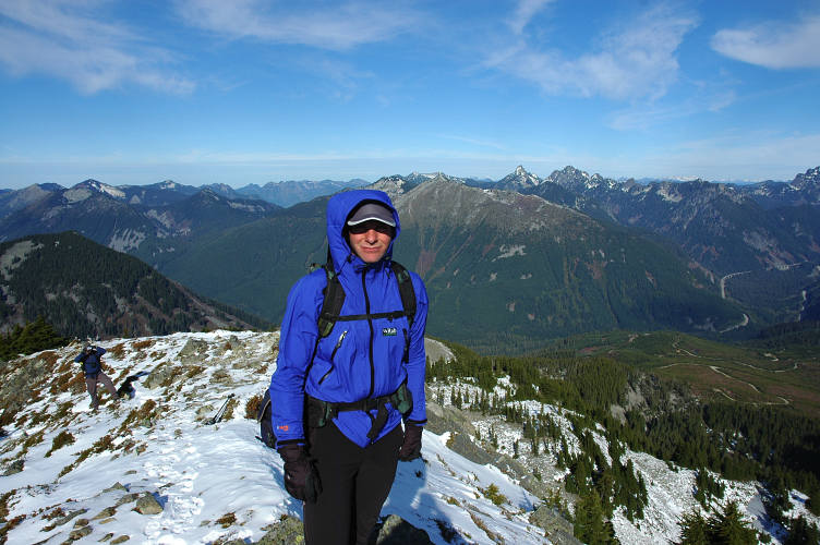
It was pretty cold with the wind, so we took a few summit photos and then scrambled 10 feet lower, where the wind couldn't get to us. I'm pretty sure Kevin got wind burn on his teeth from this pose.

Now you see how to do it right. No smile, no wind burned teeth.
Wayne was the most clever of all of us: He's completely out of the wind. You can see North Bend in the upper left corner of this photo.

Kevin was determined to see if his Windstopper Jacket actually worked, and so remained on the peak when I scampered away from the horrible, nasty wind.

We spent an hour on the summit before beginning the descent back down the talus field. Descending talus is really not much fun. Scree is ok, because you can ski it. But talus is too big, and both Kevin and I fell on our backsides on the descent. And that was about the greatest objective hazard we faced on this particular day.

After finishing the talus field and the short bushwhack, we raced off down the trail and by 4 pm we were eating burritos at the Taco Time in North Bend. Pretty civilized.
Logistics
From Lakewood, drive I-5 north to State Highway 18 and follow this to I-90. Take I-90 to Exit 47, signed for Asahel - Curtis. Make a right from the exit and then an immediate left onto a gravel road signed for Annette Lake. You'll need a NW Forest Pass or equivalent to park here. Follow the Annette Lake trail for aboiut 3.5 miles to Annette Lake, gaining about 1800 feet of elevation on good trail. Check out the lake and spy the lower ridges of Silver Peak toward the left skyline. Backtrack a few hundred yards and pick whatever line looks best through the forest. Bushwhack for about 15 minutes up the steep hill side until you reach a massive talus field, or long avalanche slopes in winter. Climb up the talus to the top of the ridge (there is only one way to go!). When you top out, you'll see Silver Peak close by. Follow a boot track just below the ridge proper (or scramble the top for fun) around the backside of Silver Peak. Climb up to the broad summit. Be aware of avalanche danger, for there looks to be a ton on the route. The summit ridge can be heavily corniced in winter, so be very careful. It took us 3 hours to get up, including 1.5 breaks, and 2.3 hours to get down, with 1 break. The total distance is about 4.5 miles car to summit and gains 3,800 feet.