Mount Washington, Olympic National Forest
July 8, 2006
Two weekends in a row in the Olympics, two weekend of fabulously clear, blue skies. I knew that I was either getting the benefits of previous suffering from the weather, or I was incurring a debt that would have to be paid to whatever organization decides upon the weather in Washington. There were nine Mountaineers, myself included, standing in the dusty road beneath Mount Washington in the Olympic National Forest, gearing up for what was supposed to be a simple alpine climb up a prominent peak next to Mount Ellinor.

Having been up Ellinor four times before, only once in good weather, I knew the views that were coming. Ellinor is a very popular mountain, for there is a solid trail all the way to the top, the climb is short, and the views superb. Washington, slightly higher, stands next to Ellinor and has a beat-trail for part of the climb. More scrambling, more scree, far fewer people. We took off through the woods, ascending the rooty trail rapidly, slowing only for the scree and talus slopes that began appearing with frequency. The scree was not so much a danger for the climber, but rather for those below. The people in the group did an excellent job of spreading out and being careful on the scree and no one took a shot from above. Views off to the west of Rainier, Adams, and St. Helens quickly came in as we left tree line for rock and snow.

The snow obliterated the climbers trail we had been following in a basin, but it was easy to see where to go. A large ridge in front of us was the target, for it would lead directly to the summit. After climbing up a few class 3 gullies and traversing some remaining snow banks, we emerged onto the top of the ridge line and explosive views of the heart of the Olympic range, including my friend, Olympus, from last weekend.
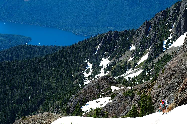
The ridge was snow free and the walking, though exposed, was simple and safe, assuming you were not prone to tripping over your own feet. Arriving at the base of the summit, we decided not to directly climb to the top, but rather to traverse around the block on a two foot wide ledge and then ascend a moderate gully to near the top. Two hours and fifty minutes, including breaks, had gotten us up from the road in good style.

It would have been a feat of no mean magnitude for someone to spot a frown on any of the faces on top of the summit.
Photo courtesy of J. Myer

It wasn't just the weather or the amazing views of most of the major peaks of Washington: Olympus, Baker, Shuksan, Glacier, Rainier, Adams, St. Helens. From the top we could see Seattle and Tacoma, various islands in the Sound, sparkling Lake Cushman far below.

Everything in the state, it seemed, could be seen from the top. It wasn't just the normal summit euphoria that brought forth so many smiles. No, from the very bottom, from even the drive in, the entire process had been fun. Washington was a peak I could do by myself. But the process of the climb would have been much diminished without the jokes, laughter, and constant bantering of the people involved.
Across the way was Mount Ellinor and, with the help of binoculars, we could spot a large herd of goats rapidly descending the snow bank near the top. Several groups of hikers were on the top, lounging in the sun, enjoying the equally fabulous views from there.

It was with some sadness that, after forty minutes on top, we began to shoulder our packs again for the descent back to the cars. It was still early in the day and the weather was so fine that one might be tempted to spend the night on the top of the peak, just for kicks and to see the stars and lights of Seattle come out. But descend we must, which meant facing the scree slopes once again, but which also meant that we were heading for cold beer and fatty bar food.
Photo courtesy of J. Myer

Logistics
From Lakewood, drive I-5 south to HWY 101 and take this through Shelton to the town of Hoodsport. In the middle of town, make a left onto SR 119 at the signed junction and head toward Lake Cushman - Staircase. Drive about 11 miles to where SR 119 hits a T-junction. To the left is Staircase. Make a right and drive about 1.5 miles on a good gravel road (a few potholes) and then make a left turn on yet another gravel road, heading up hill. There isn't much of a sign, but the road is hard to miss and there is a sign (in the other direction) just past it. Drive up about 8 miles, passing the lower trailhead for Mount Ellinor, which has a sign on it, and the turn off road for the upper trailhead to Mount Ellinor. Park a few meters further on where the road clearly ends for most vehicles. The road is narrow, but is in good shape and my Camry would have no problems with it. You'll need a Northwest Forest Pass or other parking permit (like a Golden Eagle Passport) or risk getting a ticket.
Pick up a trail across the road heading steeply uphill through slightly overgrown, rooty terrain, with a few rock scrambling sections. It is easy to lose the trail, so be careful. Occasionally you'll be spit out into open basins, but the first few miles of walking are mostly in the trees. Reach a significant creek. Cross it and continue the increasing scramble, frequently on unpleasant scree, up to an open basin where you can see most of the Mount Washington summit. From the basin, head a little to the right and then up snow slopes (early July) and then to the left to gain the ridge top. Follow the ridge, being careful with the scree and scramble sections, to gain the summit of Washington. You can follow a nice ledge system around and then up, or climb the summit directly (harder). Total gain is about 3200 ft in about 2.5 miles. The terrain is not overly technical and the peak is a good destination for people with moderate skills and looking to avoid the crowds on Ellinor.
After climbing, stop by the Model T restaurant, located at the intersection of SR 119 and US 101. The jo-jos were of preposterous size.