Central California: Kennedy Meadows to Mather Pass

June 10, 2003
Yes, this really was like Christmas morning. I
was up later than usual, but still with the sun. I had no idea where Sharon,
Will, or Glory were as I had slept next to the river and they did not
find me in the night. It didn't matter at all, as I knew we were all heading
into the mountains today, into the Sierra Nevada. The Range of Light, as
John Muir called it. I didn't have to walk far before finding my friends:
Glory and Sharon were talking with Paw, the man with the car, near the
established campground at Kennedy Meadows (I was down by the Kern in
some grass). Will arrived, as did Tin Cup, an Appalachian trail veteran
and all around fun guy. Splitpea and Tracker Dan stopped by for a moment
and then continued into the hills beyond. The five of us milled about,
which seemed odd given the excitement that we all felt for
the Sierra. On the verge of gaining what we had been hiking 700 miles for,
we hesitated. I do not think it was the weight of my pack (which would
not have been bad if it was being carried in one of my other, standard
packs). Rather, I think it was the apprehension of the future: Could the
Sierra be as good as the desert? Would it live up to the expectations
that I had heaped upon it? I do not know what the others were thinking,
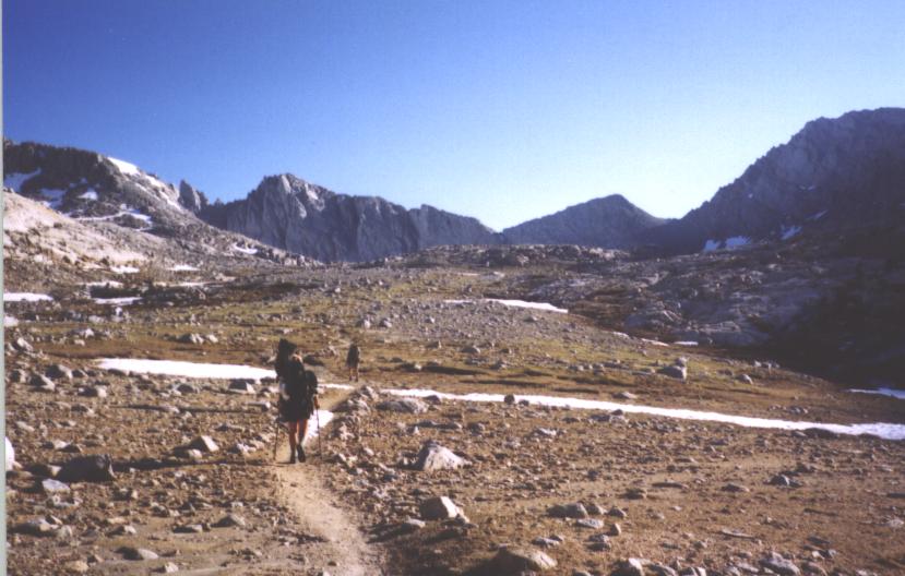
but, following a picture , I started in. Note that in the below
picture, I am standing on a rock above the others.

Today would be all uphill, climbing up to 10,000 plus feet. From Kennedy
Meadows to Mount Whitney it was a distance of 60 miles. I was planning on
climbing Whitney, which meant that I had three easy 20 mile days in front of
me. There was no reason to hurry, as it would be best to climb Whitney in
the early morning and I could not reach it, with this load, in two days without
pushing myself harder than I liked. Slowly the trail wound up into
the hills, sometimes in the shade of big trees, other times out in the open
with the sage and views stretching on for miles.
Despite coming through the hottest and driest part of southern California without
a scratch, I ran out of water right away in the Sierra. From all that I read,
the Sierra was supposed to be bursting with water. Not so, at least hear.
Streams that were listed in the guidebook were utterly disgusting, and I
found myself pounding uphill with an intense thirst in my throat, exacerbated
by the knowledge that the next reliable water supply was several hours
away. The trail topped out and began its run through Monache Meadows, one of
the largest meadows in the entire Sierra. Contrary to what I normally thought
of as constituting a meadow (lush, green grass with plenty of flowers),
Monache was dry and filled with sage.

It did not matter, however, as it also contained a string of water. Thrilled,
I dropped down a gully to the water and drank my fill, not bothering to treat
the water. Although this was the Sierra Nevada, it still looked and felt like
southern California: It was mostly dry and sage was everywhere. I suppose this
should not have come as much of a surprise, as Kennedy Meadows was a
political divide rather than a geographic one: The land to the north of
Kennedy Meadows looked much like the land to the south of it. Only, in this case,
I knew that in two more days I would reach the highest point in the continental
US and begin the true, High Sierra.
Late in the day Will and I decided to stop and cook dinner, not wanting to cook
where we camped. It was time to start taking bear precautions.
We were only planning to walk another three miles and now,
before the last climb of the day, was the obvious time. Besides,
the heavy pack was hurting my shoulders. Sharon milled about,
deciding to rest with us and take another break later to cook. The others
were far ahead. Or, at least, somewhere out of sight. The land out here
was so large, that once someone left your sight, a strong sense of
solitude and isolation dropped over you. In southern California, one could
generally see the trail for miles. Now, with the more mountainous
topography, I could only see the next few (sometimes hundred) yards.
Resuming the climb, I quickly passed another thruhiker, Trippin' Ant, and
reached the Monache Bowl, the place where I wanted to camp for the night,
less than 22 miles from Kennedy Meadows. In camp were Split Pea, Tracker Dan,
Tin Cup, and Glory, all busy cooking dinner. I stood thinking for a while,
before deciding to stay. The others seemed oblivious to their invitation to the
bears in the area, but they were there first and, if I did not like it, I
could simply walk on. I was tempted to move forward, as Trippin' Ant did
when he caught up, but eventually decided to stay in this nice spot.
Will arrived and was not happy about the cooking either, but decided to
stay as well. Sharon eventually came in and decided that this was the
place also. As a result, we have a large group camped here tonight, with new
faces and old. Stories were passed about and Splitpea renamed Sweetpea.
Tracker Dan became Buttercup. Of course, no one would call them by these
names except for us, but it was fun none-the-less.
As the light dimmed and our fire dwindled, I set off to bed with a chill:
It was cold out here, colder than it had been since the start of the trail.
I was wearing most of my clothes and inside my liner, in my sleeping
bag, and was still a bit chilled. My sleeping bag was rated to 40 degrees,
and the air temperature was already well below that. My sleeping pad had
seen a few too many nights before this trip to insulate me well from the
cold ground. This was the first night in the Sierra, and I had already
realized that a warmer bag would be preferable. Snuggling down
deep within my sleeping bag, I drifted off into a fitful, unrestful
sleep. The cold accounted for some of it, but my worries about bears and the
next few days occupied my thoughts. Gone were the deep sleeps of
southern California; idle, sweet Southern California.
Cold. This was one of the first mornings that I could not get going before
the sun: It was simply too cold to get out of my bag without the sun up. Not
that it was warm in my sleeping bag. Glory had gotten up around 5 am, taken
down her tent, and started hiking, presumably because of the cold. When I
finally emerged around 7, it was in a hustle: Must get moving. Not because the
day would be long or I wanted to hike a lot before the heat of the day. No,
I needed to start hiking to start generating some body heat. Will and I set off
together and immediately ran into a medium sized black bear foraging in the
undergrowth perhaps 75 yards from our camp. Slowly the land warmed and Will and
I found Glory with Trippin' Ant lounging in the sun next to a small creek.
Thoughts of the upcoming night began to worry me a bit. Not because I was in
any danger, but because I would be uncomfortable for at least part of the
night. I should have brought my warmer sleeping bag, at least for this
leg.
Leaving the warmth of the creekside sun patch, I began my slow climb up
toward the ridge above me, moving slowly as this had been predetermined
to be a lazy day. Covering 20 miles in a day is fairly routine, even in the
Sierra. The others passed me quickly, although I later re-passed them hanging
around a tower of rock, climbing on its sides for views off into the distance.
Something, however, told me that there was a special place up ahead. That I
had to keep going, because the land was going to reveal something important.
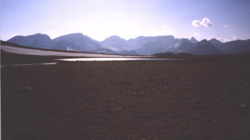
Less than a mile later, I came upon a massive cleft in the Sierra ridge and
looked down upon a purple and orange valley, with red and tan rock in the
distance and, obscene as it might seem, green and pale blue patches far below.
Not the green of grass or the blue of a lake, but more of the color of
science fiction. Something unnatural was going on down in the valley.
Which valley?

It was the valley of the Owens. Now it was a stark desert.
It used to be a highly productive agricultural community. Many years ago,
of course. It had been destroyed to feed the growth of Los Angeles when the
LA aquaduct was conceived and built. In the early part of the last century,
Los Angeles was growing beyond the means of the land to support it: There
simply was not enough water to support the people living there, the
industry that made things work, and the agriculture to feed everyone.
Water had to come from somewhere and people came up with the scheme of
building an aquaduct and diverting the flow of some large river.
The easiest river to grab was the Owens, flowing down the east side of the
Sierra Nevada before turning south. The city fathers bought large parcels of
land and farms from the inhabitants of the valley under various guises.
No one suspected that the purchases were simply to gain the water rights and
that the river would soon be diverted. After all, this was good, productive
land. Why would anyone want to destroy it? To the city of Los Angeles,
it was not so much destruction that was going to happen, as it was
sustaining life. From their perspective, they needed to the water to grow
and expand. A city which does not grow, dies. At least, this is the
rationale that they employed. When the farmers of the valley finally
learned what was to happen it was too late. Gun fights broke out and
people died trying to resist the growing power of the city. In vain
was their struggle, as the aquaduct was built and the river diverted.
The aquduct brought the water to the south and the west, watering
massive industrial farms along the way and giving the people of Los Angeles
bright, shiny green lawns. A trade off was made. But, one of the parties was never
consulted on what they were giving up.
The Owens valley was the subject of the class film noir, Chinatown,
and there are many well written books about the events surrounding the
aquaduct and the water of the west in general. See, for example,
Cadillac Desert: The West and its Disappearing Water by Marc
Reisner. This is a (mostly) well written book, but shows a certain
amount of bias in its scope. Perhaps its most interesting, and
important, sections are on the Bureau of Reclamation chief,
Floyd Dominy. See also Beyond the 100th Meridian by
Wallace Stegner. This chronicles the life of John Wesley Powell, perhaps the
most influential early figure in the battle over the water of the west.
I sat for a long time at the cleft in the rock. My friends moved on, but
I remained where I had stopped hiking, slightly hidden from the wind behind a
rock,but with a good view out to the Owens Valley. I was unsure of how I
felt. On the one hand, I had one of the grandest views that I had ever
come across. I tried to recount the contenders: A mid December morning on top
of Wildrose peak in Death Valley. The icy neck of Ama Dablam during sunset
in Nepal. The first time I saw the Milky Way in Kings Canyon. The volcanic-alpine
duality of the Mount Edziza massif. The Spectrum Range. This was certainly
up there. However, it also occurred to me that I was looking upon the
destruction of a land and its community. That the beauty cast up from
so far down below could not have been there without the suffering of the
people that lived there, and the avarice of people that lived elsewhere. Without
the loss of life and the unnatural death of the land. However, it was
also true that the water did go to help at least some people. Because of
the diversion of the water, farms (albeit industrial ones) were irrigated
and the land made to bear vegetables and fruit and grain. But, it would
have done so, and probably more efficiently, had the water remained in
the Owens Valley. People did get water for use in Los Angeles, but look
at what they had done with it. Was Los Angeles a better place to live
now? Given the choice of the Owens Valley or Los Angeles, I knew which place
I would choose.
These thoughts haunted me, or rather flowed through me, for the rest of the
day. It was good that my friends were far ahead of me now: I wanted to
be alone and think. Walking through beauty has that power. Beauty inspires
the mind, no matter in what setting or where it is found. I had found
beauty in the destruction of a community, and yet it inspired me to try
to think about how a large body of people might be able to live in an
environment and not destroy it. How can we live without destruction?
Perhaps, it occurred to me, it is not possible to do so on a large scale.
Other times it seemed that small changes in how we live, in what we
desire, would produce profound changes in the environment, both for
better and worse. The day had almost ended when I passed Sharon resting and
ran into Will, also resting. Glory had apparently disappeared, as she was
supposed to be between the two of them and I had not passed her. There was a
trail that branched off to go down to a parking lot (many miles later), from
which you could hitch to Lone Pine, a small community east of the Sierra.
With the temperature dropping, I had no desire to sit around and wait for
Glory. She would have to take care of herself. As if to punish me for my
lack of feeling, the trail ran along the east side of a ridge, completely in
the shade. My chill continued as the trail ran above Poison Meadows,
crossing many small creeklets of snowmelt along the way.

Glory caught up with the rest of us, realizing that she was going the
wrong way when the trail she was one began to descend steeply. Finding a
campsite was only marginally more difficult than in Southern California,
though the presence of the snow melt indicated that this ease would not
go on much longer. Directly above Poison Meadow, which would, not doubt,
be boggy and filled with bears, was a rocky, broad hill, on top of which we
found a nice clearing with lots of rocks and downed trees, behind which
we could hide from the wind. It was not long before I was nestled into
my sleeping bag, hoping for a night warmer than the current temperature
predicted. The Owens valley remained in my thoughts as I tried to
sleep. Is there a better way? As I began to lose consciousness, this
simple phrase was distilled out of the morass of competing ideas and
thoughts. It was not simply limited to the land, but to life in general.
Maybe this was the question to answer first.
I awoke with the others with an intense desire to be by myself. I was feeling
antisocial from the first moment of the morning and did not know why. I think that
the magnificent land around me was drawing me inside of it, trying to pull me in.
With other people around, I would resist this. I didn't want to any longer. I
wanted to lose myself in this massive, irresistible land. Others, no matter
how much I liked them or cared for them, were holding me back. Or, rather,
I was not developed enough to resist their pull. This was one of the
fundamental lessons about myself that I had learned so far this summer.
What was more important was whether or not I would be able to push past
this problem. But, for now, annoyance was rampant in my mind as the
others would stop when I would stop or hike right behind me.
I was able to separate myself from the others for a large part of the morning,
particularly after going over Cottonwood pass, supposedly the first potential
rough snow place on the trail. As there was not a sign of snow to be found
anywhere near by, I was feeling positive about the future. However, shortly
there after I crossed above Big Whitney meadow, one of the most spectacular
sights thus far.

I could see what was up ahead. Snow was up above, clinging to the passes and
flanks of the granite range. I would have some work to do in a few days. Walking
through Big Whitney lifted my spirits immensely and the antisocial feeling
had passed: I had gotten enough of the land to satisfy myself for a little while.
I lunched with the others before beginning the steep climb up to the plateau
which would eventually run into Crabtree meadows, the launching point for
climbing Whitney. To make the summit day easier, I and the others had
planned to hike above Crabtree to Guitar Lake, cutting off a thousand feet
of elevation gain from the summit day.

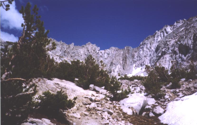
On top of the plateau, the world spread out before us. At this elevation there
were still trees, but few of them. The rocky land vaulted up in mountains or
fractured into passes, all of which were a delight which, when paired with
the alluringly faint pine scent and sudden chirps and barks of the inhabitants of
the woods, became a complete sensory experience. All alone, I sat and leaned up
against a dead tree, trying to take in the entire land with a glance, trying to
sum it up in a word. Many people believe this to be a fools errand, that some
things are too grand to be captured in a few words; too powerful to be constrained
by a short burst of human thought. I disagree. After all, what else is a haiku
or poem, but the expression of something deep in only a few words? Art has as
one of its purposes the condensing of beauty into a form manageable for
human consumption. I felt like an artist, sitting in a patch of rubble,
leaning against a dead tree.
Will and the others arrived, and I became a hiker again. Afternoon clouds
were gathering over the Whitney area, the very area that we were heading into.
From my other experiences in the Sierra Nevada, I knew the chances for
afternoon thunderstorms were slight. I knew that they just didn't happen here.
But as we neared Crabtree meadows, I could see the lightning dancing in the
high peaks above.

Upon reaching the meadows, a sign directed us off the PCT to the ranger station and
campground. Being a backcountry sight, there was not much here. But, as I
was deciding how to cross a creek, I heard my name called out. Looking about,
I could not see the sender of the greeting, but, once on the other side,
I found Tin Cup smiling and happy and sitting next to a small fire. Jeff and
Mountainhouse were there as well, two new hikers for me to meet. With my
party of four and the other three, it was a large group indeed. With the colder
air, I did not relish leaving the warmth of the fire and the others set out
in front of me, determined to make it to Guitar Lake. I would see Jeff and Tin
Cup again, as neither was planning to hike up Whitney. They might go into
Lone Pine, a town a long way out, or maybe not. Regardless, I would see them
at least in Vermillion Valley, a long six days off. I began my climb up to
Guitar Lake and quickly ran into the others again. A creek had to be crossed
and there did not appear any way around in or over it. They had been searching for
a while. I took my shoes off and crossed, while they found various ways to
get across. It would be the last time I would remove my shoes for
a stream crossing.
Guitar Lake was in a true alpine land. Tufts of grass and moss clung here and
there, but the dominant features were the rock and the snow and the ice.
The lake provided an awesome view of the distant mountains in the west, with the
sun slinking down, splashing the lake with its color. There was a group of section
hikers above the lake where Glory had stopped. I was cold and becoming grumpy and
so left, wandering down to the lake and finding a partially protected campsite
amongst some rocks, but with the spectacular view mostly preserved. I set
to work improving the wind protection and saw Will and Sharon above me
with Glory and the others. I did not care if they came down or not; I would
be happy alone, or with company. But, I was cold and wanted to get into some warm
clothes and into my sleeping bag for the long, cold night. I avoided getting
water on the grounds that I could easily get some tomorrow. It would be a mistake
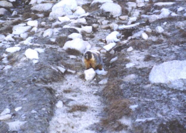
that would cause me some discomfort tomorrow, however. A fat marmot wandered
up, the first that I had seen thus far. Fat and jolly, the marmot sat eating
flowers not far from me. I said hello and waved to it, but it did not change
its habit. It just chewed and chewed and occasionally looked around.
This irked me, for some reason, so I told it to haul ass on out of here.
It still didn't budge, as if it didn't hear my threat. Anger built inside of
me and I chucked a rock in its direction, which sent it scuttling off
for a safer environ. Happy and distressed at my battle with the
obsese ball of fur, I began to get comfortable as the others arrived.
They decided to camp with me down by the lake rather than above with the
others. We talked of the need for an early start, given the afternoon
storms we saw earlier today. We talked of the need to hike on after
summiting Whitney. But, mostly I sat quiet, looking at the fearsome
land around me, watching the stars come out, and trying not to shiver.
I could feel the cold coming through the rock beneath my flat sleeping
pad. I would not sleep well tonight, I knew.


I did not sleep well. My Z-rest is completely flat and it did a very poor job
of insulating me from the cold, cold rock that I was sleeping on. There was barely
any light by the time I was off and moving, with the others nearby. The trail
was mostly buried in snow, except for when it emerged on rock, but the general
direction was fairly clear. Given the temperature, the snow was like ice, with
little traction where it was smooth and this proved to be difficult in
areas. When walking where others had walked before, the footing was fine. When
walking where others had not gone before, the footing was non-existent. Early on
in the climb, I decided, for some unknown reason, not to take the trodden path
and instead take a more direct route across a snow slope. It was only twenty
yards, how hard could it be? A few steps out, I realized that I was close to
falling and could not turn around. The very light ice axe that I was carrying
was soon working hard cutting steps in the icy snow. Weighing only 8 oz, the
axe is good for a long hike where it will usually only be used for self belay.
However, when called to cut steps, its light weight and small adze made the work
long and tedious. It would usually take me four or five hard strokes to get a
very small notch for my toes to fit in. I got across, but it took me a lot
longer and a lot more effort than the less direct, but trodden path. What would
Robert Frost think of all this?
The others had taken the direct route and were now ahead of me, which was fine.
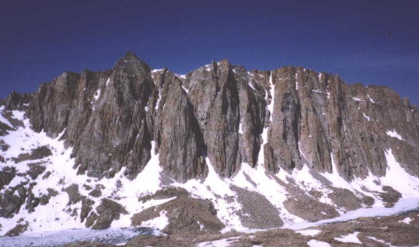
I liked the solitude, here in the first really class mountain scenery. The vault of
the Sierra, with its frozen lakes and icy spire, presented a powerful image to
my eyes raised on the midwest and only recently fed desert style scenery.
My head began to throb and I realized that I had not filled up with water before
leaving camp. It was so cold in the morning that I didn't remember to get the
previous liquid. The previous few days had seen me slack off from the southern
California routine of drinking massive amounts of water. While this wouldn't
normally be a problem, I was at the moment ascending about 13,000 ft. and the
beginning gnawings of altitude sickness were coming on. The primary, and
perhaps best, defense against altitude sickness is to take in large amounts of
water. I didn't even have the water to slake my growing thirst. Stumbling up
hill, the hike became less pleasant still as I reached the junction where
hikers coming up from the east side (the standard walk) meet hikers coming
up from Guitar Lake. Traffic increased, and I no longer had the mountains to
myself. Joined by day hikers and a few John Muir Trail hikers (the southern
JMT terminus is Mt. Whitney), I struggled along the trail, with the top my
only focus. I hated hiking this way. It seemed more rewarding to
be sitting at home looking at photographs. I wasn't questioning my PCT hike;
I was questioning why I was hiking up Mt. Whitney. It was the highest point in
the contiguous United States. What an awful reason.
One last push up a snow slope brought the Smithsonian hut into view, with
Glory, Will, and Sharon milling about next to it. The view from the top was
glorious, but perhaps not worth the effort to get to it. To the west, south, and
north, the Sierra spread out in limitless fashion, giving the impression of
an immense distance from anywhere. To the east, though, was what I was interested
in. I had stood on Wildrose Peak in Death Valley several times before, gazing at
the grand spectacle of the Sierras to the west. Now, I wanted to look back east
to the desert. It was not to be had: The early morning start meant that the
sun was still striking me in the face and very little could be seen. The faint,
brown outline of mountains to the east, the dry valley between them and the Sierras,
and a road running through it was little compensation for the trouble of
getting up here. Glory was kind enough to share some water with me during the
hour we spent at the top.

I was not unhappy leaving the top of Whitney nor were, I think, the
others. We were all feeling mild effects of the altitude and the increasing
number of day hikers at the summit were making things less pleasant. I straggled
on the way down, passing an increasing large stream of hikers on the way up. I
shuddered to think what this place might be like on an August weekend. On the
way down, Will and Glory decided to glissade down a slope rather than walk around.
Will went down in good form, with experience from his time living in
Golden, CO, and a trip into the San Juan's a summer ago. Glory, from
middle Tennessee, went down in a most odd fashion. Not knowing how to use her
axe to glissade or to self arrest, she would slide down on her rear until
she felt she was going too fast. Then, she would pivot around and swing
her axe, like a pick-axe, into the snow behind her, stopping with a jolt.
The comedy of watching her go down the slope was great indeed and after we
were all together again, Will and I showed her a few things about using her
axe. Glory, at times, had that rare quality of being able to laugh at herself and
she took our peels of laughter with a smile. Passing near Guitar Lake I stopped
to drink some water, so much longed for on the climb up and now in abundance. The
sun was out and warming my young bones as I drank deeply from a small trickle of
snow melt. No iodine in this water for me. I was drinking straight from nature
and the intellectual delights in this for me were great, as was the pure taste.
I would not treat my water again, I thought.
I was the last to reach Crabtree Meadows, the others being in various states of
sleep or eat. As much as I wanted a nap to combat my headache, I cooked a lunch
of noodles first, with Trippin' Ant rolling in shortly after I began to eat.
He had also camped at Guitar Lake, but had gotten a later start than we did.
With my belly full, I tossed out my ground cloth and went to sleep in the sun.
I sublime pleasure of sleeping in the green grass, after 700 miles through
the desert, was not missed. Except for the occasional chirp of a bird or the
bark of a rodent, not a sound was heard past the whistle of the wind through
the trees. An hour passed before I began to stir. Sharon was packed up
and moving out. Glory, Will, and Trippin' Ant were still asleep. I packed
up quietly and was moving just as Will was waking. I wanted to make it to
Tyndall Creek, about a 10 mile walk, for the night. There was bear box there
and it was only 5 miles from Forrester pass, the beginning of the difficult
pass hopping in the Sierra.
I enjoyed several miles of quiet hiking through the woods with views of the
Sierras, pondering the hike up Mt. Whitney and why it struck me as
incongruous with my hike. Why it stood out as something out of place. I
had reached no conclusions when I ran into Sharon cooking a pot of
instant potatoes at Wallace Creek. I think we were both enjoying the
solitude and were somewhat put out by seeing each other. Not that we
didn't like each other; not at all. Just that both of us were looking for something
that was hard to find when others were about. Will and Glory soon showed up,
and the four of us set out to cross the Big Horn Plateau, a place that I'd
been looking forward to for a year. The plateau stretched for several miles in
each direction and was covered by rock and gravel with intermittent fields of
grass spread throughout. A few shallow alpine lakes dotted the landscape.
The plateau was guarded by the black rock (black at this afternoon hour) of
the Sierra and its attendant ermine robe of snow. The sun was sinking toward
the mountains and casting the perfect light over everything. I stopped in my tracks
to let the others pass forth. Here was beauty personified. It is said that
beauty is in the eye of the beholder; meaning that beauty is a subjective thing.
I could not imagine that there was a single human being who would not find this
place, at this time, the most beautiful place in the world. I thought to myself
that this is where I want to retire to. I don't want to live in the woods and
fish everyday, I just want to throw a tent down here, right in the middle, and
sit for days and weeks. To be only here, and nowhere else.

The spell broke, and I began to walk again. The plateau was finished and the
day was almost over. I found the others staring at raging Tyndall Creek, occasionally
glancing up to see the bear box and the trail on the other side. It was the first
real stream ford of the trip so far. Not too deep, although quick. Keeping
my shoes on, I walked across without incident, the others following. With soaking
feet and falling temperatures, the four of us quickly sought out our homes for
the night, battling off a few marmots whose natural fear of us had been overcome
by their curiosity or hunger or both. Even a hail of rocks would not drive them
away. Their barks and whistles could be heard throughout the early evening,
accenting the soft swaying of the trees. Tomorrow the hard trail would start.
It didn't matter, here on the ground, though. Thoughts of the perfection of
Big Horn Plateau danced through my head, blotting out the stars from my eyes, and
casting a vision of the future perhaps more powerful than the memory of the past.
Today is the day. The day that the High Sierra becomes a reality, rather than a
line on a map or a dream in my head. Forrester Pass would start that process.
The highest point on the Pacific Crest Trail (Mt. Whitney is not on the trail
itself) at a little over 13,000 feet, it was the first real obstacle for Central
California, the equivalent of
Scissors Crossing and the San Felipe hills in Southern California. It was along
this stretch of trail that in 1999 a PCT hiker died. He had gotten off the trail
trying to head out of bad snow conditions to resupply in one of the towns on the
east side of the Sierra. Apparently, he walked out onto a cornice (sort of
like a shelf built up by wind driven snow) and had fallen through. The injuries
he sustained caused his death not long after, but with enough time for him
to write a last letter to his family. Jonathon Ley has an account of it in
his journal. The thought
was on my mind, despite knowing that this was a much safer year as far as snow
was concerned.
The trail leading up to Forrester involved climbing, not surprisingly,
but the immediate approach broadened out into a flat expanse, with the
gash that was Forrester Pass highlighted in the distance. Snow could be seen
just below it. Snow that was in a dangerous place and would require some
care to negotiate. Will powered forward, confident in his navigational
ability, with Glory not far behind, and Sharon and I bringing up the rear. It
was the start of a common theme for the pass hopping of the High Sierra.
Will was unnaturally gifted with navigational abilities and seemed to always
know which way was the right and proper path to get to the pass. Although I
would read the map and try to figure out which way to go, I almost always
just followed Will's tracks in the end. As the trail climbed above the
approach plateau, bits of it began to be covered in hard snow. It was still the
early morning and most of the south side of the pass was still in the shade.
As I approached 13,000 feet, more and more of the trail was obscured, reaching
the point where it was no longer practical to try to follow a trail: When the
trail became completely buried, head straight up hill until an uncovered switchback
is found. With 80 vertical feet remaining, I ran into the snow covered gully
that I had first spotted from the plateau. A triumphal howl from Will announced
that he had reached the top. The snow was hard and icy, but the
hikers in front of us had tromped some footholds into the snow. The crossing
would prove dangerous only with a fall. Don't fall, I thought. This is the
one place today where I absolutely can not fall. I kept the chant inside my
head, rather than passing through my lips, and made my way across the
snow. With about ten feet of snow left, I heard Sharon call out from
behind, "Hey, turn around and smile!" No, no, I protested. I can't at this
moment. I was afraid to shift my weight or do anything other than maintain
my current position. I heard the clicking of a camera as Sharon snapped a
photo of my backside and reached the safety of rock. I turned to watch Sharon
come across the snow, waiting to make sure she made it safely. Once she
was out on the snow, I could see my thoughts running through her head, as
apparent as an advertisement for McDonald's on the side of an interstate.
When she got across, she told me that she understood.

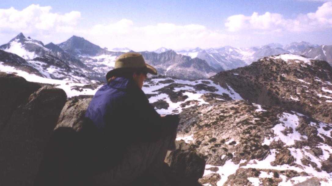
The top of the pass was only a minute or two away, and we found Will and Glory
there, basking in the sun on top of the high point of the PCT. This pass marked
the boundary between Sequoia and Kings Canyon National Parks, commonly
referred to as a single entity. In the fall of 2000, I had taken a three
day trip
in Kings Canyon with Eugene Lerman
and Lisa Traynor, while we were visiting the
American Institute of Mathematics. I fell in love with the Sierra Nevada
during that trip, as difficult as it was for me. It was the trip that convinced
me that in order to enjoy the outdoors, at least in the way that I wanted to,
I needed to improve my physical condition. Upon my return to Illinois,
I began running and that has forever changed my outdoor experience. While I
would not be moving through the same area on this trip, my previous connection
to Kings Canyon made me feel at home here.
Looking down the north side of the pass, all was white. All was snow, except for
a bit of a frozen pond far down the slope. Will proclaimed the outlet to that
pond to be about where he thought the trail should be. Getting to it was another
matter entirely. There was no visible trail, only a variety of tracks heading off
in different directions, but toward the nominal goal. The white expanse was broken
up by a few fingers of rock, which might provide some respite from the snow. Unlike
the south side of the pass, the north side was completely exposed to the morning
sun. The snow would be soft, which would make for tough going.
Sunglasses came out and additional clothing came on for the descent: It was
clear that descending would take more time that climbing, and the wind was blowing.
Even with the sun out, the temperature was low. Will set out, followed a few
minutes later by the three of us. At first, the snow was not too rotten and
the footing was firm and good: Soft enough to get traction, hard enough to
support our weight. As we began to descend, the snow began to worsen. I caught sight
of Will glissading down a snow slope toward the lake, but thought it best to
stay high, gain the rock, and then descend it, hoping to avoid as much of the snow
as possible. The rock proved to be firm, but difficult. Leading down the
rock, I was nearly hit on several occasions by large rocks coming down from
Sharon and Glory above me. There was no way to avoid it. I simply had to
be alert to their calls and move as best as I could. Climbing down through the
rock eventually became tiresome and the snow looked better. Plopping down on
my backside, I glissaded to lake level, and then began to follow Will's tracks
to its outlet stream.

With each step, my leg would plunge to my knee, if lucky, and my hip otherwise.
The snow was so rotten near the lake that my foot would hit bottom with a velocity
just short of falling. On lucky steps, my foot would eventually hit snow and
I would come away with only a slightly jolted knee. On unlucky steps, my food
would bounce off rocks or hit the sharp end of one, resulting in a hurt foot or
ankle. On many occasions I toppled over from the combination of a long footfall
and an awkward landing. My trail runners provided little protection to my feet and
ankles from the sharp rocks underneath and I quickly began to tire of the snow and
wish for some honest rock to traverse. After a long half hour, I reached the safety
of trail, right next to the outlet stream of the lake, with Will's grinning
visage as a welcome respite from the sterility of the White. Trudging forth, the
snow faded mostly and the majesty of the park unfolded around me. Looking
forth, I could see the general route for the rest of the day: Down to
Vidette Meadow, across it, and up the other side. We had been warned by
various hikers from 2002 that Vidette Meadow was prime bear country. Without a
bear box to be found, and none of us with bear cannisters, camping in the
meadow was not an option. Glen Pass, on the other side, had to be crossed today.
I was tired and in awe of the land around me. A dry bit of grass next to a snow
melt stream provided a nice breaking point. The others pushed on for, seemly
full of more energy than I could muster at this point.


I welcomed the interlude of solitude as a chance to mentally recuperate from
the descent of Forrester Pass. I was tired, but not worn out. The stroll across
Vidette Meadow and a lunch break would serve to replenish my stores of energy,
which would be needed for Glen Pass. Low in Vidette Meadow, I came across the
other three, preparing for lunch in a spot with enough sun for warmth, but
enough shade for comfort. I spread out my sleeping bag and groundcloth to
dry from the previous night's dew, and ate lunch: A liter of Bombay lentils,
which I had cooked five months ago, dehydrated, and was now devouring. Little
was said at lunchtime, with the others apparently as tired as I was after
coming off of Forrester pass. With the sun moving through the heavens faster
than desired, I had to leave lunch earlier than desired. Forrester Pass had
required more time than I thought it would and the other side of Glen pass was
still far away.
Vidette Meadow provided another hour of flat walking, before the trail
began to climb toward Glen pass. Several thousand feet of elevation had to be
gained before the climb to the pass could begin in earnest, although this
climbing was through pleasant forest and was snow free. Shortly after beginning
the uplift, I ran into two hikers, both in their mid 60s. They were carrying
massive external frame packs and moving at about a half mile per hour. While I
blew by them, with my now reasonably weighted pack, I couldn't help but be
struck with a ray of hope. They were out here, hiking and climbing and
enjoying themselves at an age when golf and blue-tinged hair were on the
minds of many of their peers. When I was thirty or forty years older, I too
wanted to be out here. They gave me hope because they showed that this was not
an unreasonable desire. Others were doing it; so could I.
The route up Glen pass went by and above several lakes, before seemingly
ending in a cirque of high mountain walls. No pass could be seen and no escape
was evident. Where did the trail go? Will and Sharon were far ahead of me, I
thought, and Glory far behind. As if responding to my worries, the trail
disappeared beneath snow from time to time, although never for more than forty or
fifty feet. I could follow some of the tracks from Will and Sharon, but at
other times they hiked around the snow patches.

As the climb wore on, the small notch of Glen pass became evident: I knew where
to go, even if I could not find the trail to it. Forrester pass was a large and
prominent topographical feature. Glen pass was a small break, a little nothing.
Will's howl again announced success and indicated that I was neither as far
from the pass as I thought, nor he and Sharon as far from me.
Glen pass was one that you would only see once you were close to it and I was
convinced that whomever found it initially did so while they were lost. A last
push put me on top, where Will and Sharon sat, resting and enjoying the expansive
views back to Forrester and north toward the Rae Lakes, the next big feature on
the map and one of the most popular places in the park. At this time of year,
however, I suspected that not a single soul would be found, unless we happened
to stumbled upon some other thruhikers. This was our land now. Only
thruhikers would be out here in the snow and comparative cold, dealing with
buried trails and hard stream fords. It was a magical place in August, I suspected,
but right now it was close to perfect. The snow gave everything a look of difficulty
and beauty, and there were no hoards to share it with. As a community, the
thruhikers of this year (and every other year) owned this perfect land in as
much as any land could be said to be owned. It was ours by right of occupation,
to be passed on to others when the time came, hopefully a little better than
when came across it. It would be here forever, hopefully, and many future
generations would be able to own it in the same way.
After thirty minutes, Glory had still not arrived and the three of us were
beginning to chill with the wind and the cold. Sharon agreed to wait behind on
the pass for Glory, although all of us recognized the futility of this. If
Glory didn't show, what could Sharon do? She was at a full day of travel
from the nearest road, from which a hitch into town would be difficult.
No, this waiting served little purpose. Will and I headed down the
snow covered slope, with little trail to guide us and soft snow to plunge through.
As with Forrester, we were heading for a small lake at the base of the pass, from
which we thought we could pick up the trail again. Step after step became an
exercise in frustration. My ankles took a several beating, only less so than
my feet. My feet had been wet since fording Tyndall Creek the night before,
and now they were cold and battered. Will and I split ways, both in search of
better footing. Reaching swampy land at least, I could see Will's pack
bobbing up and down in the brush, not far away. There were many small streams
to leap or to ford, with still no trail. Not that it mattered. The trail
was somewhere in the narrow valley we were descending. As dictated by the
topography of the land, it quickly did, just before reaching the Rae Lakes.

Will and I sat to wait for Sharon and Glory, hoping that they would not be too
long. Both of us wanted to get as close as possible to the next pass before
ending for the day. Woods Creek was within reach and was the start of the
climb up to Pinchot Pass. There was a bear box there and its low altitude
would mean the first warm sleep I would have in several days, and the last
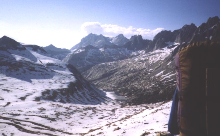
for a few more. The Rae Lakes were stunning, with large spires of rock
soaring above the frigid waters. In the prime summer time, this place would be
a wonderfully relaxing swimming hole, with plenty of scrambled up the rock
faces evident. This beauty, when combined with its relative accessibility
(it was a short day's hike from Road's End in Kings Canyon), meant that
many people would come here, and with the people would come the bears.
Signs dotting the lakeshore admonished people not to camp in certain
areas, to make sure they cleaned their fish somewhere else, to store their
food in such and such a way, and warned against a myriad of other
actions. In this most protected of lands, freedom was most restricted. An
odd irony that was not lost on me. For now, though, they were meaningless:
There was no one here, and the warnings were in place to protect the land
during the crush of visitors that would be coming in a month or so.
Sharon and Glory appeared a half hour later, with Sharon looking not too happy.
Glory had decided to take a long break below Glen pass, which caused her
delay in reaching the pass and Sharon's long sojourn at the top, in the wind and
cold. We set out at a quick pace down the sloping valley toward Woods creek.
The land of rock and snow gave way to a lush, green swamp-like forest and the
first mosquitoes of the trip. A few buzzed here and there, biting as they
could, though still not mature enough to get through my thin clothing. The sun
began to set and my body spent its last energy a mile before the creek. Reaching
the Death March stage of a hike is always unpleasant. The mind turns off from
the world around it and can only think of the physical discomfort. The
body becomes numb, and eventually the mind deadens as well. The soul and
spirit of a persons sleeps, and all that is left is a moving shell, a husk.
Nothing matters except moving forward, except gaining the goal that will end the
day. Woods creek was reached with only a faint light remaining. Despite
reaching the goal, I could not restart my body or my mind. I sat on my
Tyvek and ate some cookies. Few words were spoken between us, although
Sharon was able to point out the orange tents pitched not too far from us,
near the bear box. The day was hard, and tomorrow
was going to be more of the same. Sleep came fast and deep, the warmth of
the air acting like an opiate upon my usually cold and now spent body.
The morning came far too early, even with the deep sleep that the warmth of
the lower altitude campsite provided. My body, but more importantly, and
my mind were still weary from the near 26 mile day before. Pinchot pass
was calling, and it was a long uphill walk in order just to reach the
base of the pass. Even more, I wanted to get to the other side of the
next pass, Mather. This would be a shorter day than the previous one, but would
involve more elevation change and probably as much snow. I crossed the
suspension bridge across Woods creek as the world began to light up, with
every one in front of me. For long, slow slogs up a hill, company is
best left: The additional burden of being with others is, at times, too
much on a long climb. The climb up toward the pass ran along a raging
river, ringed with high peaks, all of which cried out to be climbed, or
at least worshiped in some other distinctly human way. A sort of
pagan ritual, I suppose, is the ascent of a peak. It is a way of honoring
the natural world which is so unresponsive to human endeavors. It is a way
of being significant, at least for a moment, in an otherwise massive world.
I would not climb, but rather move through, the area. Upon reaching the
plateau before the pass, the trail was buried completely in snow. I could not
see the others, and tracks ran in every direction. A bit of trail would pop
out now and again, providing at least some direction. The plateau was so broad
and there were so many potential passes, that the right general direction
was hard to discern. I wandered to the end of one meadow, then wandered back.
To the bank of a lake, and then in the opposite direction to another. Eventually
I spied Glory and Sharon, looking equally lost, across the way and moved over
to join them. Will was not in sight and the two did not have the trail either.
We moved in a direction that we thought proper, then turned a right angle to go in
another. There were several cirques, each of which held places, high above,
that could be a pass. We tried one, then another, climbing along the
high rocks that split each cirque into separate entities. No luck. Sharon and
I poured over the maps and scanned our respective compasses, but without being
able to find the right way. Glory stood by, waiting for some stroke of
luck, perhaps as good of a technique as ours. As the morning passed, tempers
began to breakdown, particularly between Sharon and Glory. Glory was sure the
trail was over in one direction, but could provide no evidence of this or
even a reason, which infuriated Sharon. More wanderings ensued. Eventually the trail
was spotted across a valley, in the right general direction as Glory had thought.
She eagerly pronounced that she knew that she was right, which irked Sharon
and I. Not so much because Glory was right, but because of the gloating that
was in her voice, though not in her heart. I don't think Glory is capable of
such a vice, but the feeling remained. An hour passed and we regained the
trail. Another hour of climbing along trail or over rock or through snow.
Will's howl of success penetrated the still air, far off in the distance, although
in the direction we were heading. I distanced myself from Sharon and Glory,
moving as best as I could and reached the top of the pass where Will sat,
thoroughly rested. I promptly dropped my pants to moon the valley below
Pinchot pass, which had proved so much more difficult than the pass itself.
The valley hadn't done anything to me. I had just gotten lost and so my
anger and frustration really should have been directed toward myself. But,
this is something difficult, and useless, to do. As Will's chuckling from my
actions subsided, we sat to chat while waiting for Sharon and Glory. He had
not gotten too lost and mostly found his way straight to the top. The others
arrived at the top, happy and relieved to be done with the valley below.

The descent down Pinchot pass followed the now standard routine: Spot the
lake at the base of the pass and head to its outlet stream. Will and I
began the descent, with Glory and Sharon following after resting much less
than Will or I. Although getting to the top of Pinchot pass had proved to take
twice as long as I thought it would, the snow on the north side of the pass
was still firm enough to keep the postholing from getting to bad and the
snow itself ran out faster than normal. Pinchot pass should have been easy and
quick, but getting lost soaked up quite of bit of time and made it one of the more
tiresome. Crossing the outlet stream of the lake and beginning the traverse of
the valley separating Pinchot from Mather pass proved to be a joy, although wet.
Several icy stream crossings were required, although everyone's feet were still
wet from the snow of the previous few days. An open, sunny spot for lunch
provided a nice place to eat and recharge and dry out my sleeping bag and
groundcloth from the condensation of the night before. Will set out for Mather
pass well in advance, hoping to make it rather far today: He was running low on
food and was hoping to make Vermillion Valley Resort, the next resupply place,
earlier than we first anticipated. Glory and I strolled together through the
meadows and forests, with Sharon somewhere behind.
Upon reaching the plateau before the pass, the trail was again lost in the snow.
With the morning's frustration below Pinchot pass fresh in my mind, my
map came out quickly; I was determined not to repeat the experience. Glory and
I moved slowly, but surely, through the snow, finding bits of trail to
guide up and narrowing down the possible location of Mather pass to one of
two places. One was free of snow, the other buried in it. We built small cairns
for Sharon to follow, although we eventually lost all sight of the trail in a
snowfield and could not longer provide her with help. Indeed, we were now
navigating by faith and by the occasional sighting of Will's footprints.
It became clear, quickly, that the pass with the snow on it was the correct one.
Glory and I detoured around a lake to reach the base of this pass and high upon
it we could spy bits of the trail, switchbacking like crazy toward the top. High
above, we could see a small dot that must be Will.

To try to follow the trail would be nightmare: There was too much snow and
that much traversing would prove both difficult and time consuming. There
was only one option: Go straight up the 50 degree slope, right through
the snow, to the top of the pass. I sat to smoke before setting out on this
bit of technical work. It was already 4:30 and the snow would soon begin to
harden, making the work that much more difficult. Sharon arrived and her and
Glory set out, trying to make the best of the situation. They moved slowly
up the hill and I quickly caught them after my mini break. Will's howl was
heard almost immediately. Sharon led the way initially, with Glory later
taking over as Sharon grew tired of having her always a foot or two behind.
I offered to lead, but Glory seemed intent on trying this new experience
without my aid. I let her go up, and occasionally slide down, with Sharon and
I keeping our distance from each other and from Glory: A slip and a collision
could cause a fall, which would be a rather bad thing. Each step was measured: Kick
deep into the snow. Plant the ice axe above. Step up. Repeat slowly and
carefully. This was another no fall zone. Moving at this pace and in this fashion,
the climb up was no problem, even with the snow becoming more and more firm.
At the top, as usual, was Will in full rest mode. I was surprised that he had not
pushed on, as he had been up there for a good forty five minutes.
The break at the top was, of necessity, short. The temperature was falling and
the sun was making its move toward the tips of the mountains. We had to get off
the pass and down to where camping was possible and comfortable. In standard
fashion, Will and I took the lead in heading down the snowy slopes for the
outlet stream of the lake at the base of the pass. With the snow in better
shape, we glissaded as far down as we could, before taking to the flats before the
lake.


My body began to tire and my thoughts turned to camp. Although we had only
moved 20 miles today, it had been a long day. Will was firing to hike for another
two hours, but when we reached the lower Palisade Lake and found Tin Cup and
Jeff camped there, I knew my day was done. They were deep in their
tents and I snuck up quietly to Tin Cup's. I gave a low growl, in best imitation of
a bear and could see Tin Cup twitch a bit. He stuck his head out calmly and
we both enjoyed a good laugh. The others could hike on, but I
was not to move from this spot. I had to rest and another two hours of hiking
would be wasted: The grand land through which I was moving would not be appreciated.
I began setting up my tarp to block some of the wind at this exposed sight when the
others arrived. Will was clearly dismayed by my decision to stop early. I
emphasized that the others should push on, but I could tell there was little desire
to do so in Sharon or Glory. They would move on or stay as Will chose to do.
After five minutes of standing around, Will and the others decided to stay.
I had a bit of extra food, and so gave Will a couple of candy bars. In return,
I got a couple of the best chocolate covered cherries that I had ever tasted.
While I gave the candy bars out of compassion, Will's returning the favor
with the cherries made things so much sweeter. Not because of the
cherries, but because we both understood each other. From here to VVR it is
about 56 miles and only two passes: Muir and Selden. Muir is supposed to be one
of the most difficult and snow bound of passes and Selden is supposed to be easy.
Each will have its own day devoted to it. Perhaps more importantly, there are
several massive river fords to be dealt with, and these represent a much
greater danger than the passes. Thoughts of being swept away in Evolution or
Bear creeks entertained my thoughts. Gone were the casual, care free days of
southern California, where the only worry was about carrying enough water and
if the sun would be too hot. Now, there were real threats and real things to
worry about. Although we had made it through most of the hardest part of the
High Sierra, there were still four passes between us and Yosemite, where
the PCT was supposed to lose most of its snow. If the stars were out, I
would not know it. Not only was my tarp up for the first time in many nights,
but my body and mind were too tired to appreciate them, and my spirit was not
strong enough to command the sensory driven parts of my existence to
care.