What is the Pacific Northwest Trail?
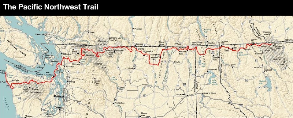
The PNT runs between the Pacific Ocean on the west and the Rocky Mountains on the east, following a line just south of the Canadian border and going across the states of Washington, Idaho, and Montana. The approximate length is 1200 miles, of which the majority are in Washington. The eastern terminus is in Glacier National Park and the western is at Cape Alava in Olympic National Park. The below map shows the PNT and was created by the PNTA.
Of course, one can start and end in a variety of places. Unlike the AT, PCT, or CDT, the PNT runs across the grain of the land rather than with it. Roughly speaking, one can divide the trail into two parts: Traveled and untraveled. Fortunately, the dividing line between these two is also close to the physical half way point. From the Glacier National Park to the Pasayten Wilderness the land the trail passes through sees little visitation from outdoor recreation types (at least once you're out of GNP). From the Pasayten Wilderness to the Olympic Coast, the trail passes through areas that are very popular with hikers and climbers (the Cascades and the Olympics) and lands that are heavily populated (Puget Sound).
When I left to start the trail in Glacier National Park I had no intention of hiking every mile of it. Rather I wanted to use the corridor formed by the PNT and instead explore the land itself. The PNT, like any trail, is arbitrary. Why confine yourself to someone else's idea of where you should go? During my trip I travelled along the PNT perhaps 60-70% of the time. I took some huge departures from the PNT and will document these elsewhere and at another time. Out of respect to others who do care I am trying to refer to my hike as a corridor hike, rather than a thruhike.