Northern Terminus of the Pacific Crest Trail
August 31, 2005
Since I was in Manning Park visiting some friends from the Great Divide Trail, I thought I'd take a little walk out to Monument 78, which marks the border between Canada and the United States and is the northern terminus for the Pacific Crest Trail. I remembered well the last day on the trail and wanted to see how well my memories corresponded to physical geography. Paula left for work early in the morning and I quickly followed her out into the cold air. It was cold enough, in fact, that I had to wear my rain jacket and hike at a rather rapid pace up the dark, forested trail. After weaving its way through bottom lands, the trail met the Windy Joe fire road, which I remembered as being never ending. Still cold, I ran up the steep road to get warm and to burn off some of the beer that I had been drinking of late. After a mile and a half, or so, the trail resumed its course through the woods, leaving the fire road just before the top of Windy Joe mountain. Fortunately, I broke through the woods and no longer had to run to keep warm, as the sun fell down across me in a gentle way.

Loping along, I didn't recall seeing any openings in the forest canopy, yet here they were. In fact, the trail held many views off into the States. I suppose my contemplation on that last day were more absorbed than I remembered. Not so today.

I reached Castle Creek and its campsite and knew that the border was only a few minutes away. I crossed an avalanche chute and arrived at the border 2.5 hours after leaving (with a nice, lazy break in the sun). The Pasayten Wilderness beckoned to the south, but it was not for me today. The Pasayten is, perhaps, the most stunning section of the PCT in Washington. With places like the Glacier Peak, Alpine Lakes, and Goat Rocks wildernesses, that is saying quite a bit. Some day I'd go back.

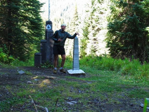
For now this was as far south as I was going, being that it is more than 30 miles to the nearest road (and then a 2 hour drive back to Manning). I kicked over the monument post, shaped like a miniature Washington Monument and dug out the trail register inside. Inside I found the entries of those hikers who had finished, or were close to finishing, or just starting out, or just out for a dayhike, like me. Captain Bivy had signed in a few weeks ago, out for a long section in Washington. He had given me a lift from San Diego up to the ADZPCTKOP in April and I made a mental note to send him an email upon my return. Bigfoot, a friend from the PCT in 2005, signed in as he finished up the PCT. He section hiked the entire trail in three years and I had last seen him, remarkably enough, in Dunsmuir. In fact, his next door neighbor had picked Will and I up as we hitched out of Dunsmuir back to the PCT. David Horton had broken (shattered) the PCT speed record, finishing in a little over 66 days. Squeaky had broken the unsupported speed record by a day and a half and was on his way to tackle the CDT, and then the AT, in a quest to become only the second person ever (Brian Robinson was the first) to complete the Calendar Triple Crown (AT, PCT, and CDT in one calendar year).
I added my own little note and left two candy bars for people to enjoy at the border. I should have hauled up some Kokanee, but it hadn't occurred to me this morning. I reassembled the monument and looked longingly at the terminus marker. This bit of wood had marked the physical end of my Beautiful Thing. It marked the end of my walk in the US. It did not mark the end of the impact of the trail upon me. With the perspective of two years time, I couldn't believe that I had walked here from Mexico, 2650 miles to the south. The physical walk wasn't the daunting aspect. Rather, the mental one seemed impossible. I smiled, shouldered my pack, and walked back into Canada.
Logistics
Manning Provincial Park is located just north of the US-Canadian border and slightly east of the main Cascade range. Highway 3 (the Crowsnest) runs right through the park. Be aware that gas stations can be very far apart in this area. Hope is the closest settlement with a grocery store and is about 70 kilometers away. To get to the trailhead, drive the Crowsnest to the Manning Park lodge. Take the turn off for the lodge and drive around the backside of it, following the sign for an assortment of trailheads (none of which say PCT). After about a kilometer or two, cross over a bridge and park on the other side in the obvious spot. From here, follow the trail. There are at least two other ways to get to the border: Via Beaver Pond and on the Monument 78/83 trail. The Monument 78/83 trail is not well maintained and should probably be avoided.