Mount Ellinor, Olympic National Forest
April 15, 2006
Springtime in the Olympics! A time to frolic with the new flowers and roll about in dewy meadows under the warm April sun. I wanted to celebrate the good weather with a walk up to the top of Mount Ellinor, one of my favorite destinations in the Olympics, complete with stunning views of the central Olympics, Hood Canal, some of the Cascades, and even Seattle.
And, a good workout. When I was last here in October the weather was not quite so pleasant, but I did get the promised workout. Along with Doug Terry, who was on the previous Ellinor trip, and two others from the Kitsap Mountaineers, I disembarked about a mile and a half below the lower trailhead and began a leisurely saunter up the road, stopping frequently to lounge in the sun and smell the proverbial flowers.
At the upper trailhead parking lot, we were quite dismayed to find that the hotel-like privy was not stocked with toilet paper, and Doug made a mental note to berate the lazy rangers when we returned to Hoodsport. After all, all they have to do is drive up the road and toilet paper is definitely an essential luxury.
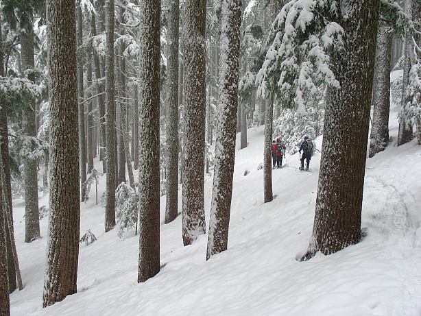
We headed up the trail from the privy, thankfully inside the protection of the forest, for the spring sun was becoming a bit too hot for our winter skin, made pale by several months of Pacific Northwest clouds.
Reaching the junction with the trail coming up from the lower trailhead, we decided that the top of Mount Ellinor would be a bit too sun exposed to suit us, and that the flowers above would not be quite the equal of those below us. Thusly, we decided to laze in the forest, taking a long and sleepy lunch break at the junction and return via the lower trail.
The lazy rangers and loafing volunteers hadn't gotten out yet to do spring maintenance on the trail and on several occasions we lost our way descending the trail. Why someone doesn't come out and paint white blazes on every other tree to mark the way is beyond me. After all, this is a requirement for hikers on the Appalachian Trail, otherwise they might get lost and wander off that rugged wilderness adventure into someone's backyard or cow pasture.

After our adventure in route finding we finally made the road and turned down it, reluctantly heading for the truck and the end of our little spring stroll. Although we hadn't made the top of Ellinor, I was quite happy with our romp to taste the fruits of Springtime in the mountains.
Watching the natural world come back to life after a long, cold, and snowy winter is a treat that everyone should sample at least once in their life, and a little exercise is something that a few people in the South Sound should try on a slightly more regular basis. It was with some sadness that we reached the truck, though our sorrow was mitigated by the fact that there was a long summer in front of the spring and that Mount Ellinor was not going anywhere fast.
Logistics
From Lakewood, drive I-5 south to HWY 101 and take this through Shelton to the town of Hoodsport. In the middle of town, make a left onto SR 119 at the signed junction and head toward Lake Cushman - Staircase. Drive about 11 miles to where SR 119 hits a T-junction. To the left is Staircase. Make a right and drive about 1.5 miles on a good gravel road (a few potholes) and then make a left turn on yet another gravel road. There isn't much of a sign, but the road is hard to miss and there is a sign (in the other direction) just past it. Drive up about 5 miles to the lower trailhead, which has a sign on it. The road is narrow, but is in good shape and my Camry has no problems with it. Continue on the road for another two miles to reach the upper trail head. You'll need a Northwest Forest Pass or other parking permit (like a Golden Eagle Passport) or risk getting a ticket.
From the lower trail head to the top is a bit of a grunt. Two guidebooks list the distance at about 3 miles, but I think this is a little short (not by too much). Vertical gain is about 3200 feet, so the hike is a bit stiff. Starting at the upper trail head cuts off about 1.5 miles and a thousand or so feet of gain. From the lower trailhead to the upper by the road is about 2.6 miles. In good weather no special skills are needed to get to the top and this would make a great hike for someone in shape, but not used to exposure.