Mount Hinman, Alpine Lakes Wilderness
August 11-13, 2006
Ever since a memorable backpacking trip along Icicle Ridge last summer I had been struck by the idea that Mount Hinman would be a fun climb to do someday. Another hike up to Spade Lake a month later cemented the idea. When I heard that Steve was leading a trip to Hinman for the Mountaineers, I jumped at the chance. Steve had led a trip to Lundin Peak that I had thoroughly enjoyed, despite bad weather and stopping 30 vertical feet from the summit due to bad, slippery rock.
Tom, whom I had hiked with to Upper Wildcat Lake and the Brothers, Kari Ann, and Colleen were fellow students from the Tacoma Mountaineers, while John was a student with the Seattle branch. From the very beginning, the mood of the group was high, with constant joking, ribbing, and smiling. I couldn't remember being on a climb that started out with such high spirits, especially given the viewless, flat hike through the woods that formed the beginning of our trek.
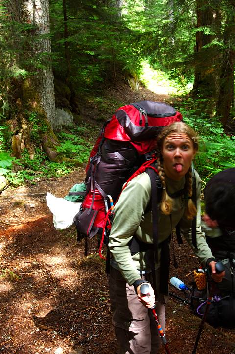
After crossing the East Fork of the Foss river on two log foot bridges, the trail became more serious as it climbed steeply up to Jade lake. The party strung out on the trail, each person moving according to their own comfort level, but we reunited at the far end of the lake in a cloud of mosquitoes. The sky was struggling to clear, and really wanted to, but clouds hung about and kept the temperatures low. As both campsites at Jade Lake were full, and the day was still young, we decided to push on past Jade, heading a bit further up the valley.
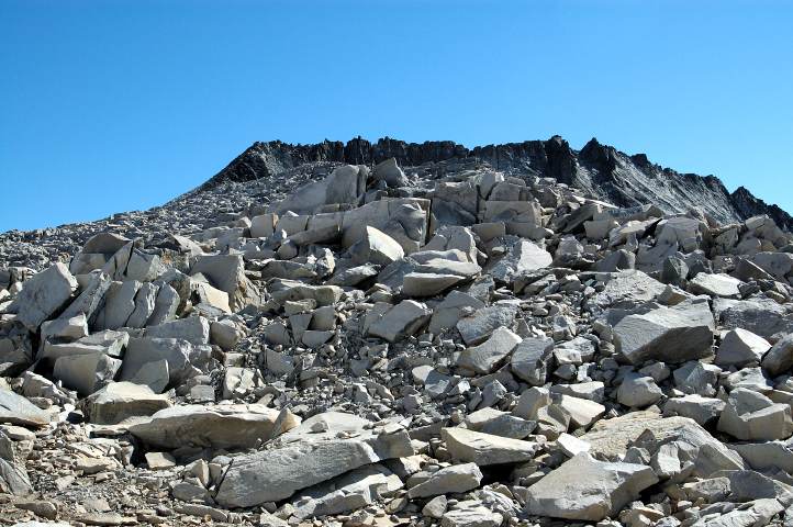
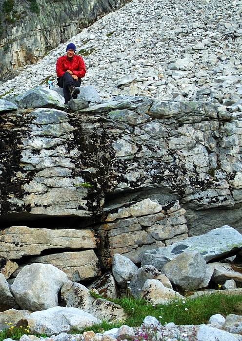
Tom and I raced out in front, passing through the swampy land next to Emerald and Opal lakes, battling mosquitoes as we went. We finally broke through the thick forest and entered into an open, slightly swampy basin below a large, steep gully that still held snow. To the right of the gully was a much gentler valley that I hoped was our route up to La Bohn Lakes, but I knew that it was not. We stopped to wait for the others, who arrived shortly after. Given the steepness of the gully, we decided it would be best to camp below it and spread out to look for a campsite. I found a nice, flat spot with a little stream in a clearing in the forest above a boulder field, but it lacked views and in the end we settled on a rocky spot with a view that Tom and Steve had found.
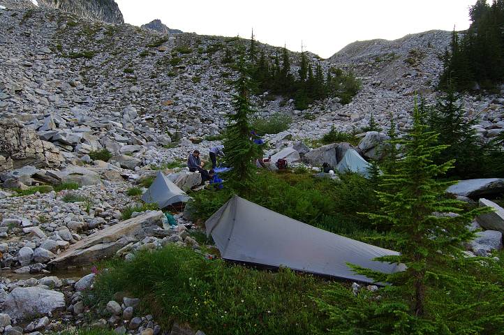
After setting up camp and dining, we got together and poured over the map to make sure we knew where the proper route lay. Although we all wanted the SSW trending valley to be the right way, it became quickly clear that the steep gully was the proper choice. The thick mosquitoes and a 4 am wake up time meant that no one stayed up much past 8 pm. I dove into the shelter of my mosquito-netted tarp and pondered the gully. The central lesson from the Sierra High Route was that things were never as bad as they looked from a distance. Still, I went to sleep with a little trepidation for the morrow.
As I always do the night before an early wake up, I slept fitfully, waking up frequently. Although low clouds had rolled in before bed, the sky was perfectly clear when the alarm on my watch rang at 4 am. It was cold out, near freezing, and it was difficult to rouse myself from the warmth of my sleeping bag to get ready for the climb. With helmets and harnesses on, we began to traverse along the talus field below the gully right at 5 am. The boulders were mostly stable and the incline of the gully appeared less and less formidable as we approached it. A few icy snow fingers required crampons to traverse across, but there were no difficulties in climbing to the left most side of the gully, where a steep snow finger sat. Crampons came on again and we began the steep (35-40 degree) snow climb toward the top of the gully. On Little Tahoma, this sort of a grade had seemed impossible. Now, I was in my comfort zone. Nearing the top, I went to place my right foot, only to find it slip. Catching myself, I looked down and found that my crampon had come off. Fortunately, I only had to traverse about 10 feet over to the safety of a boulder, but kicking steps in the icy snow took some time.
From the boulder I scrambled up on rock for a few feet, then put the crampons back on and climbed the remaining steep snow to the top of the gully. Looking back to the valley we had come from, we were treated to an amazing sight: A cloud waterfall. While the sky was faultlessly blue, the valleys below were clouded over. In the far distance, we could spy a far valley blocked from the one we had come from by a tall ridge tumbling off a local peak. At a gap in the ridge, the fog was spilling over, like a water fall, something I had never seen before.

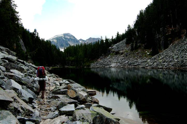
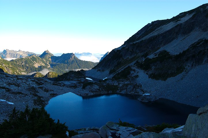
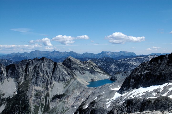
After re-grouping and looking at our map, we headed through the pass at the top of the gully for a bit before climbing up and out of it to our left. From the minor ridge, we could spot the smaller La Bohn lakes, colored a deep gun metal, as they were still in the shade. Traversing and climbing directly toward the solid wall in front of us, we soon found the largest of the La Bohn lakes sitting far below our feet. An absolutely perfect specimen of the alpine tarn, it would have made for a perfect, bug free, but very cold campsite.
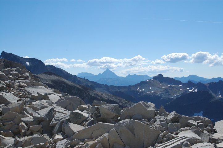
Picking up a cairned climbers track, we headed up to the wall and began ascending it via a sequence of ledges and easy class 2 scrambling. The footing was solid, with good holds, and the cairns made route finding easy. As we gained elevation, more and more of the countryside came into view, including the awesome massif that is Bears Breast. It seemed the whole of the Cascades could be had in our view, and the view got better and better as we went higher.
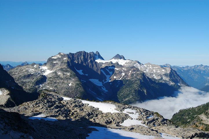
Mount Baker came into range, along with Glacier Peak and the entire Monte Cristo Range. Bears Breast blocked the view back toward Rainier, but through a gap we could spot a bit of white that had to be part of that big, fat volcano. After a well deserved break, we continued to scramble through the wall and into the rocky land above it, eventually coming to a solid avalanche gully that brought us to a high shoulder and a view to the southern lobe of the Hinman glacier.
It took some time, however, for us to verify that this was, in fact, the Hinman. Smaller than most glaciers that I had been on, the Hinman had no crevasses or blue ice, or any obvious sign that it was anything other than a big snow field. However, it couldn't be anything else according to the map. We lounged for bit in the sun, putting on sun block and sun glasses, clowning around constantly. It was hard not to be in high spirits given the location, views, and perfect weather. A few muscle jokes, in honor of Kari Ann's husband Peter, were, of course, made.

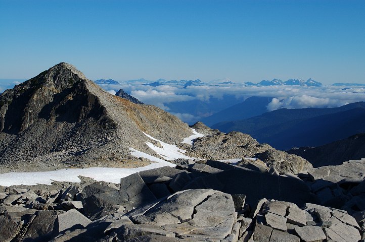
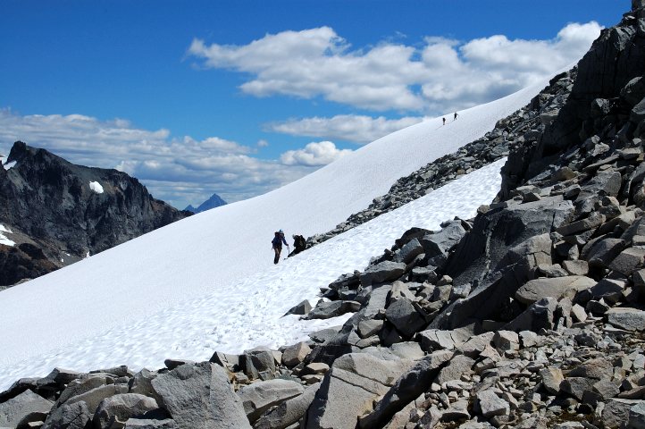
We eventually dropped down to the snow and roped up. We zig-zagged down the glacier heading toward a small, partially frozen lake, before cutting over to a small snow-tongue that ran through a ridge separating the two lobes of the glacier. The snow-tongue led us, after a little rock scrambling, complicated by the crampons on our feet, to the next lobe, which was much more substantial. We took an ascending traverse, switchbacking frequently, and slowly Mount Hinman came into sight for the first time. A large, choss pyramid was on our right, but it couldn't be Hinman, though I wished it to be: It looked far easier than the serrated ridge that was on our right. Maps, however, rarely lie.
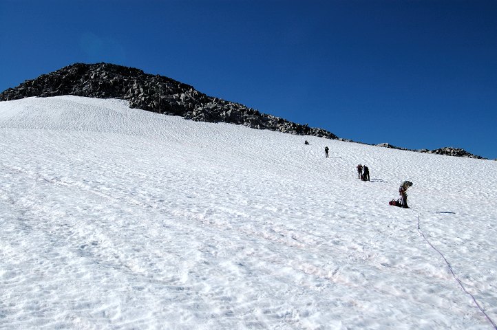
Mount Hinman is really a long ridge line of small peaks, all of which are within a few feet of each other. Looking carefully, I spied the tallest one toward the middle of the ridgeline, and this assessment matched up with what the others had found as well. Near a small gap on the left side of the choss pyramid, we unroped and lightened our packs of non-essential climbing gear. The beta we had indicated that the rest was just a rock scramble, so we left our crampons, ropes, and pickets on some rocks; the beta that we had indicated that the rest of the climb was just a rock scramble.
As it didn't look feasible to reach the left most part of the ridge and scramble along it to the true summit, we traversed along boulders and talus on the right side of a ridge, heading toward the summit and, hopefully, a reasonable route up a gully to the summit. As we moved along, the jagged pyramid of Mount Stuart, the second highest non-volcanic peak in Washington, was a constant companion.
The traverse took quite some time and as we approached the Hinman ridge, the gully route to the summit looked worse and worse, instead of better and better. Rather than a scramble, it seemed that vertical cliffs would halt upward progress near the top. Therefore, we moved along to the left most side of the ridge where we hoped we'd find something better. Loose, unstable rock brought us high up onto the leftmost side of the ridge, where John and I found a solitary scrambler who had come up from Dutch Miller Gap. He told us the true summit was not far off, but we'd have to go back down and traverse along the snow on the backside of the Hinman ridge.
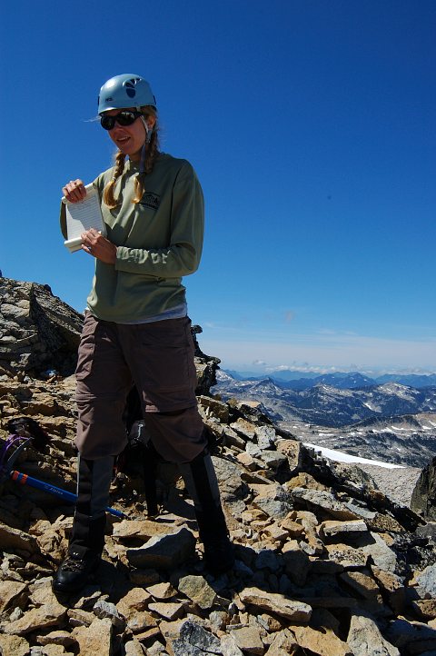
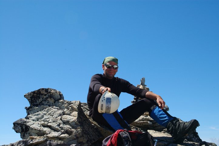
When Steve got to the top, we gave him the info and headed back down the unpleasant rock. The snow on the backside was perfect for kicking steps, and John, Steve, and I took turns kicking, and re-kicking, huge steps in the snow on an ascending traverse. Midway through we thought we had found the true summit and climbed the snow steeply to the base of a rocky pyramid. I found a small face climb that led only to a several thousand foot drop off. John found something similar. Steve found a round about, sketchy climb that did lead to the top of the local summit, but also found that a close by peak was actually taller. We dropped back onto the snow, traversed over, and easy scrambled thirty vertical feet to the true summit, finding a register in place.
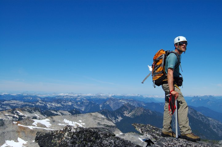
Reaching the summit launched the spirits of the party even higher. The Alpine Lakes Wilderness is about as visually stunning a mountainous land can be, and from the summit it didn't seem possible for them to be equalled by any place that I had ever been. We took turns signing the register while gazing out on the vast land, so close to the Olympia-Tacoma-Seattle-Everett megaplex, yet feeling so remote.
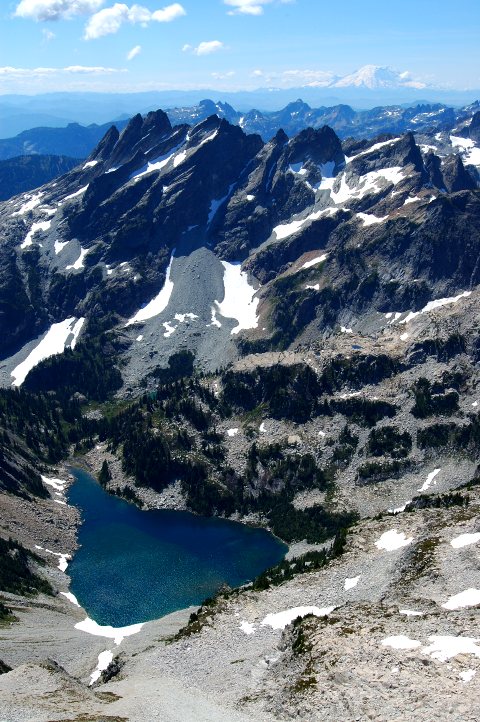
Mount Daniel, the highest point in the immediate vicinity, loomed up close by. A gorgeous turquoise lake sat below it, un-named on our map but, again, was a perfect specimen of the type. No trail led to it and I filed it away as a future destination.
Mount Rainier, in all its glory, could finally be seen completely, rising with its massive bulk above the jagged rock forming Bears Breast. Nowhere could be seen the hand-of-man, except for the bit of pipe that held the register. No trails, no power lines, no roads. Only a patch of clear cut forest, far in the distance, indicated that man had ever set foot in the region. Millions of people lived close by, yet a stranger to the peak would never suspect it.
Peering over the edge of the summit ridge, we could see the hopelessness of a direct attack on Hinman. A rock climber, with a rope and a lot of skill, could probably do it. Two thousand feet below sat yet another perfect, tear drop shaped tarn, also unreachable by trail. Seeing so much wilderness is good for the soul, especially in the modern world, where the Earth seems so small and wonder and wandering, as virtues, seem nonexistent.
There are still wild places on the planet. These places can be in the backyard of one of the largest metropolitan areas in the United States. One of the crowning achievements of conservationists in the US was the Wilderness Act of 1964. The amount of land that has been protected with the wilderness tag is staggering, especially in a states like Washington or Alaska, and it is to this land that people can return, if only for a short time, to a more simple, primal existence. Trails will take some into it. Others will follow simple boot or animal tracks. Some will go where the foot of man has never trodden. I was happy sitting on the summit in the sun and the wind, gazing out over the vastness of the Alpine Lakes, staring north to the jagged spires of the Glacier Peak and Henry M. Jackson Wildernesses. South of us sat the William O. Douglas and Norse Peak Wildernesses. Much of Mount Rainier National Park is designated as a wilderness and, around it, sits, though not visible from here, the Indian Heaven Wilderness. Some of the peaks in the far north, surely, were inside the North Cascades National Park, almost all of which is designated Wilderness, or in the Pasayten Wilderness.
Eventually we had to leave, though I was sad to do so at 1:15. We dropped back down the snow slope and traversed over to the gap below the first false summit we had gone up. Instead of taking the same route back to our gear, we tried staying on the other side of the ridgeline and found the going much easier and much faster. We retrieved our gear and, instead of returning on the Hinman glacier, we climbed to the top of the choss pyramid and picked up faint cairns indicating the climbers route.
With weary legs, we scrambled around on the talus and through the boulders, down to the La Bohn lakes, and then to the top of the steep gully that we had first climbed early in the morning. The snow, unfortunately, had been in the shade for some time and we found the footing very poor. Rather than putting on crampons and descending the steep gully, Tom and I scouted out a route down a rock rib, descending quite a ways. Unfortunately, we soon became cliffed out. John scouted out a descent via a tight gully and, when he didn't return, we figured it went and tried it as well. The loose rock and the narrow constriction of the gully meant that the lower members of the party were dangerously exposed to the rock fall caused by the upper members. It was only with great care that everyone emerged safe and sound from the gully. John was waiting on a near by rock for us. Very tired and thirsty, we stumbled over the last of the boulders and reached camp at 6:30, 13.5 hours after setting out.
Although tired, it had been a good day, full of many different kinds of terrain and spectacular scenery. Most importantly, we were all in good health. Second most important, we didn't have to hike out tonight. For now, we could stuff ourselves with food and drink all the water we wanted. The only thing lacking was a bottle of whiskey, but neither Tom or myself had been clever enough to pack one in.
Logistics
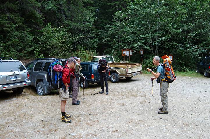
From Lakewood, drive I-5 north to I-405, and take this usually clogged interstate to SR522. Follow SR522 east to its junction with US2, and follow that through the town of Skykomish. A few miles past Skykomish, make a right on FS Road 68 (Foss River Road). The road turns to gravel after a bit, but it is in good shape. Pass under the Burlington Northern Railroad. A little ways past a major intersection (keep straight) you'll find the trailhead for the East Fork Foss River trail. Park here. You'll need a NW Forest Pass or other parking permit.
Take the East Fork Foss trail. The trail is fairly flat for about four miles and then crosses the river on two log foot bridges. Past the second bridge is a small boulder field that you have to ascend. There are cairns marking the way, but when in doubt follow the footsteps in the redwood dust. The trail now climbs aggressively over about 3 miles to reach Jade Lake. There are two campsites at either end, but it is best to continue on past Emerald Lake (where there is a run down shelter) and all the way beyond Opal Lake (which you won't see). Camp below the big, obvious, scary looking gully (holding snow in mid August) wherever you can (nothing good), or, if you have time, ascend the nasty gully (will take a little time) to reach La Bohn Lakes.
The gully isn't as bad as it looks. The leftmost side of the gully holds the best route, though it will involve some 35-40 degree snow. Crampons are required if the snow is even moderately hard. At the top of the gully, continue on, bearing slightly left until you can spot the southernmost (and largest) of the La Bohn Lakes. Near its far end you'll pick up a cairned climbers track to Hinman. Follow the cairns as best you can. The ascent to the southern lobe of the Hinman glacier is straightforward, mostly class 2 scrambling.
The southern lobe of the Hinman glacier is fairly small. Rope up and descend the glacier a bit to a snow tongue that runs through a ridge. Do not descend all the way to the small lake. Pass through the snow tongue to the next lobe of the glacier. Ascend this, heading toward the upper left. Make for a saddle in between Hinman (on the left) and a choss pyramid on the right. Unrope here, but you might want to bring harnesses, a rope, and some pickets with you, possibly crampons. Definitely an ice axe. Scramble class 2 choss and talus, keeping on the left side of the ridge (the right side is passable, but more difficult and longer), aiming for the low point below the leftmost peak on the Hinman Ridge. Although it looks tall, this is not the true summit. From the low point, traverse on the snow on the backside of the ridges, climbing snow up to 30 degrees to the far end of the ridge to an inconspicuous looking peak. You;ll definitely want an ice axe here and might want to rope up, though the run out on the snow slope is very kind. Scramble up thirty vertical feet to reach the true summit, where there is a register. If you have to do anything hard, you're on the wrong peak.
On the descent, bypass the Hinman glacier if you wish by following the climbers track over the choss pyramid, staying to the right of it. The ascent from our camp to the summit took 7.5 hours, but could be done a lot quicker (we took the right side of the ridge and climbed the wrong summit twice).
This is not the route described in Beckey!