Ingalls Peak, Alpine Lakes Wilderness
July 7, 2007
South Face
There should have been crowds. There should have been flocks of climbers heading for one of the most popular climbs in the Alpine Lakes. We should have been racing for the base of the rock to skip ahead of slower parties. Instead, we found no one. While there were plenty of cars at the trailhead, where Tom and I bivied the night before, there were no climbers. Except, that is, for three friends of ours that we found bivied at a trail junction before starting their attempt on the West Ridge of Mount Stuart, a much longer, much more involved climb that Ingalls Peak, where we were heading. And then three more climbers that we met at Ingalls Pass who were also headed for the West Ridge. The sky was clear, the air warm, and we had the rock to ourselves.

Three weeks ago we tried Ingalls in nasty conditions. As in getting snowed on and never seeing the peak. There were scads of climbers then. There was only us now. We dropped down from the pass, finding much less snow than three weeks ago, and also finding a herd of mountain goats. Led by a big, strong male, the numbered five, which was also about the number of seconds that it took to become annoyed by them.

They came upon us as Kevin changed from approach shoes into boots and would not leave. A small kid and two yearlings kept the alpha male on guard, eyeing us warily and getting closer than we would have liked. We kept our distance as best we could, but the herd circled around us, forcing us into greater and greater contortions to keep away. They wanted something from us, but none of us could give it to them at this particular time.

We finally eluded their pincers movement and made rapid progress to Ingalls Lake, still mostly covered in snow and ice, and proceeded rapidly up the snow and rock to the base of the Dogtooth Spires. Unlike last time, when visibility was limited to about 50 feet, and when the snow was in excellent condition, the morning brought long vistas and hard snow that took some effort to move over. The whole interior of the massive Alpine Lakes Wilderness was visible from the notch at the base of the spire. Mount Daniel, with a heavy mantle of snow, anchors the interior and is the largest peak in the wilderness. Next to it sat Mount Hinman, which Tom and I had climbed last August.
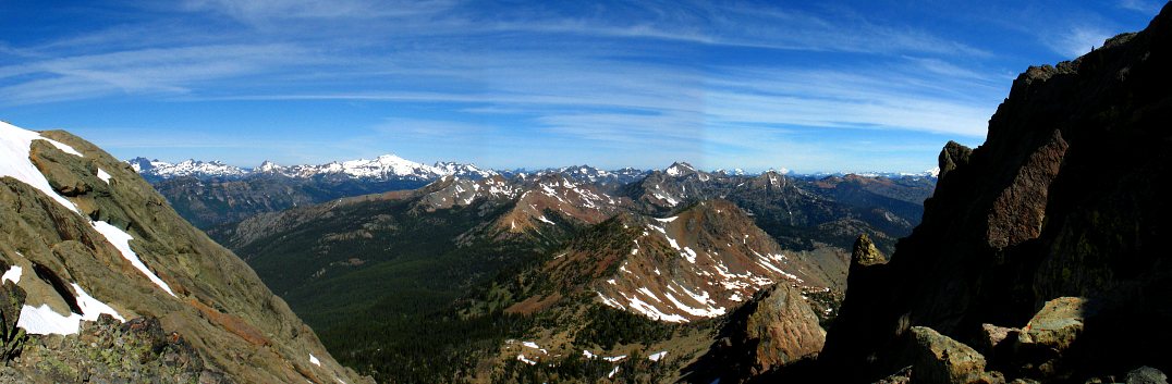
Far to the north sat Mount Baker, with Glacier Peak tantalizingly close. Southward held Mounts Rainier and Adams. We sat and gawked for a while before taking a faint climbers trail down and around the other side of the notch to bypass the Dogtooth. A short scramble up a bit of rock brought a gasp from my lips when my head popped over the flake we were climbing on: The exposure on the other side took my breath away, so unexpected was it.

We dropped and consolidated gear for the few pitches of rock climbing that it would take to reach the top. Both Kevin and Tom are better climbers, but I was leading, was on the sharp end of the rope, which meant it was also time to start concentrating. We built an anchor and a few minutes later I was leading up the wide crack, my eyes on a bolted rappel station that I could see high up on the face.
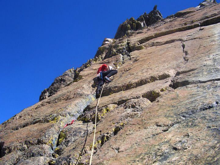
I climbed fifteen or so vertical meters, taking care to avoid the ultra-slippery green serpentine that coated part of the rock, to a large platform where there was a large boulder slung as a rappel station. I eyed the route up and contemplated continuing on, but decided that the zig-zagging route would have too much rope drag for comfort and instead brought Kevin and Tom up.

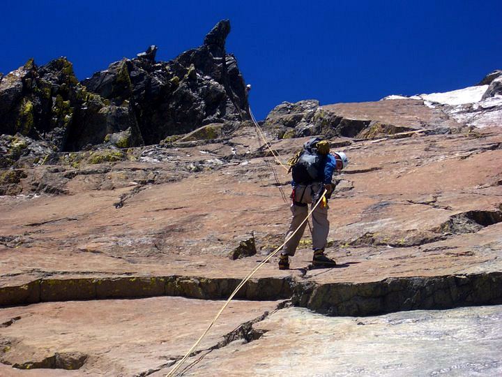
As we were a party of three, and none of us own a Reverso, we were climbing with a rope running from me to Kevin, who would belay me up, and then a rope from Kevin to Tom. Kevin would clean the protection that I placed, and then belay Tom up. While not especially elegant, the scheme worked well, with the only problem being rope management.

The two cruised up and I re-geared for the next, longer pitch. A boot-wide crack provided fun, easy climbing to a ledge where I could traverse a little right and gain another crack.

Another wide crack on the far right side of the face held more fun climbing, with some interesting exposure at a point where I had to step onto the other side of the face for some better foot holds.

I reached the top of the crack and moved a bit to the right again to gain another crack that looked appealing. Someone had apparently had to bail off the route at this point, or had some problem rappelling, as I found a three point anchor built into the wall, complete with what looked like slings tied with overhand knots. I check out the anchor, pronounced it good, and clipped it on my way up, leaving it for Kevin to pillage.

Keeping my eye on the rap station above, I moved up the crack, which narrowed and thinned as I moved up. The climbing was becoming more difficult than expected, which meant that I had gotten off the standard route. After all, the Mountaineers bring Basic Climbing students here, and they climb in mountaineering boots. I had missed some traverse or other bypass, but didn't especially care as the crack was working. I worked up the crack slowly and ran out the last twenty feet to the rap station, not for lack of protection, but just to sequence through things nicely. Stopping to place gear protects you from a fall, but also increases the chances of a fall while you dicker around with a nut or cam. The rap station had a ledge big enough for two, but not three. I brought Kevin up, who told me that the route moves further right on small ledges, then comes up, then comes back left to where I was. I got gear back from him, and he then belayed me over to a big crack system where I could hang out on a rock (protected with a nut) while Tom climbed up. Tom took the direct route that we had, in his boots, proving that it could be done, though it was unclear that a typical basic student in boots could have done it.

We collected one last time and I led out on the final pitch, which moved up the crack system where I had rested, and then traversed a little to the right before running up a last gully to the top. I poked my head over the top of the gully and pulled myself up to a nice set of bolts. I heard voices below, which meant that other climbers had arrived. Two strong, experienced climbers had come rapidly up the peak, placing little protection along the way, thus speeding their ascent. Kevin and Tom came up and we made the short, class 2-3 scramble over to the true summit.

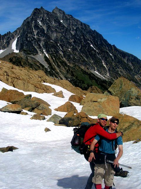
The other two climbers joined us on top in the sun for some well earned rest. Mount Stuart looked appealing, but would have to wait for us to get a bit more efficient in climbing and route finding. While I could climb my way out of anything I might find on the South Face, the West or North Ridge of Stuart would not allow such a luxury. After twenty minutes, we headed down with the other two, using a single double rope rappel to reach the base of the second pitch.
A second double rope rappel got us down to the snow level, bypassing the scrambling around on the other side of the ridge that we had done to get here. The day was still young and we took a leisurely pace in returning to Ingalls Pass, including lots of gratuitous boot and butt skiing. The standard post-climb euphoria held strong to the pass, only to dissipate as we pounded down the long trail out to the cars and, beyond, Mexican food and Negro Modelo in Cle Elum.
Logistics
From Lakewood, drive I-5 north to SR18. Take SR18 east to its junction with I-90. Drive I-90 east to Cle Elum. Hop on SR970 and take it north. Just after crossing the Teanaway River, make a left turn on Teanaway River Road and drive it for 23 miles to its end at the Esmerelda Creek trailhead. You'll need a NW Forest Pass or equivalent to park at this popular trailhead. The last 8ish miles of the road are gravel, but very nice and easily passable by a Honda Civic at 25 mph.
Hike up the Ingalls Way trail for about 4ish miles until you crest out at Ingalls Pass. From the crest, spot Ingalls Lake with Ingalls Peak above it. Contour around and head uphill, aiming for the Dogtooth Spires, which are smack on the ridgeline that you're going to climb. From the notch at the base of the Dogtooth, move to the other side of the ridge to bypass them, following a faint (but obvious) climbers trail down and then up, scrambling up to a platform where you can see the rest of the route. Alternatively, from the Ingalls Lake side of the notch, you can climb a full pitch of easy looking rock to get up to the same platform. From the platform, a short pitch (15 meters) gets you up to a rap station where there is a big, slung boulder to use as an anchor. Or, just scramble it. From the big platform with the slung boulder, climb the left most (big) crack. Once up it, traverse a bit right on a big ledge, then move up a crack that thins out as you move higher. Supposedly you can bypass the harder section of the crack by traversing to the right on small ledges, but the crack is fun enough and isn't especially hard. Gain a bolted rap station for the end of the second pitch (about 45 meters). From the rap station, move left to gain another big crack. Run this up to another ledge. Spy the gully on the left (it looks like it goes nowhere). Climb up it to another bolted rap station (about 15 meters). Scramble on class 2-3 terrain to the summit. To descend, a single double rope rappel (60 m) will get you to the base of the first pitch. Note: It is unlikely a single 60 m pitch will get you from the platform to the last rap station due to zig-zagging of the route. Another double rope rap will get you down to the snow, avoiding the scrambling around the base of the Dogtooth Spires. Note: A 50 m rope will not get you down easily! The route was more thought provoking than expected. While much of it is low 5th class (5.2-5.4), there were a few 5.6ish sections when the crack thinned out. A good, scenic climb!